Namborn geodata
Namborn (Saarland) is a seat of a fourth-order administrative division; located in Germany in Europe/Berlin (GMT+2) time zone. With population of 7,642 people, there are 2028 cities with bigger population in this country. Compared to other cities in Germany, 75.3% of cities are located further ↑North; 92% of cities are located further →East and 67.6% of cities have lower elevation than Namborn. Note1


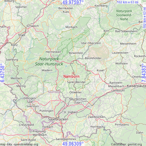
Namborn GPS coordinates[2]
49° 31' 17.976" North, 7° 8' 26.52" East
| Map corner | latitude | longitude |
|---|---|---|
| Upper-left | 49.97597°, | 6.43758° |
| Center: | 49.52166°, | 7.1407° |
| Lower-right: | 49.06309°, | 7.84383° |
| Map W x H: | 101.5×101.5 km | = 63.1×63.1mi |
| max Lat: | 55.01917° ⇑75.3% North |
| Namborn: | 49.52166° |
| min Lat: | ⇓24.7% South 47.40724° |
| min Long | Namborn | max Long |
| 5.92978° | 7.1407° | 14.98853° |
| W 8%⇐ | ⇒92% E |
Elevation
Elevation of Namborn is 340 m = 1115 ft, and this is 90.9 m = 298 ft above average elevation for this country.
| Max E: |
1256 m = 4121 ft | 32.4% |
| Namborn | 340 m 1115 ft | |
| Avg. | 249.1 m = 817 ft | |
Min E: |
-5 m = -16 ft | 67.6% |
See also: Germany elevation on elevation.city.
Geographical zone
Namborn is located in North temperate zone (between Tropic of Cancer and the Arctic Circle). Distance of this North polar circle is 1894.9 km =1177.4 mi to North.| Distance of | km | miles | from Namborn |
|---|---|---|---|
| North Pole | 4500.8 | 2796.7 | to North |
| Arctic Circle | 1894.9 | 1177.4 | to North |
| Tropic Cancer | 2900.4 | 1802.2 | to South |
| Equator | 5506.3 | 3421.5 | to South |


Nearby cities:
15 places around Namborn: (largest is in red/bold)
• Ellweiler
10.6 km =6.6 mi,  3°
3°
• Freisen
8.5 km =5.3 mi,  68°
68°
• Gimbweiler
8.1 km =5 mi,  31°
31°
• Hahnweiler
7.4 km =4.6 mi,  47°
47°
• Herchweiler
11.1 km =6.9 mi,  94°
94°
• Hoppstädten-Weiersbach
11.4 km =7.1 mi,  22°
22°
• Leitzweiler
8.8 km =5.5 mi,  38°
38°
• Marpingen
9.7 km =6 mi,  217°
217°
• Meckenbach
11 km =6.8 mi,  344°
344°
• Nohfelden
7.3 km =4.5 mi, 1°
• Oberthal
4.2 km =2.6 mi,  256°
256°
• Reichweiler
10.4 km =6.5 mi,  82°
82°
• Rückweiler
9.6 km =6 mi, 44°
• Sankt Wendel
6.5 km =4 mi,  162°
162°
• Tholey
8.6 km =5.3 mi,  240°
240°
Sources, notices
• [Note1] Compared only with cities in Germany existing in our database
• [Src1] Map data: © OpenStreetMap contributors (CC-BY-SA)
• [Src2] Other city data from geonames.org with taken over terms of usage.
• [Src3] Geographical zone / Annual Mean Temperature by Robert A. Rohde @ Wikipedia
