Nieste geodata
Nieste (Hesse) is a seat of a fourth-order administrative division; located in Germany in Europe/Berlin (GMT+2) time zone. In our database, there are 11009 cities with bigger population. Compared to other cities in Germany, 63.5% of cities are located further ↓South; 55% of cities are located further →East and 56.3% of cities have lower elevation than Nieste. Note1
Administrative division(s):
- Level 1: Hesse
- Level 2: Regierungsbezirk Kassel
- Level 3: Landkreis Kassel
- Level 4: Nieste


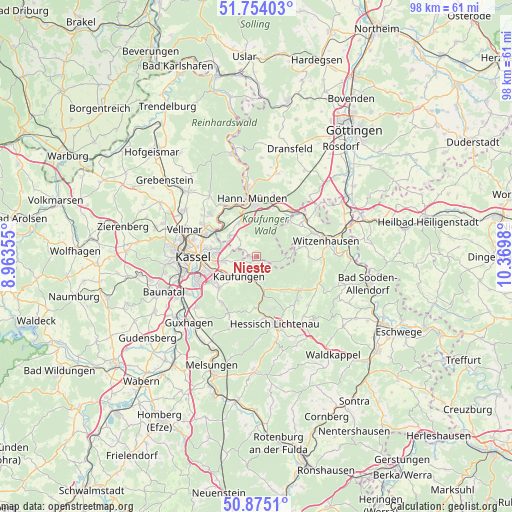
Nieste GPS coordinates[2]
51° 19' 0.012" North, 9° 40' 0.012" East
| Map corner | latitude | longitude |
|---|---|---|
| Upper-left | 51.75403°, | 8.96355° |
| Center: | 51.31667°, | 9.66667° |
| Lower-right: | 50.8751°, | 10.3698° |
| Map W x H: | 97.7×97.7 km | = 60.7×60.7mi |
| max Lat: | 55.01917° ⇑36.5% North |
| Nieste: | 51.31667° |
| min Lat: | ⇓63.5% South 47.40724° |
| min Long | Nieste | max Long |
| 5.92978° | 9.66667° | 14.98853° |
| W 45%⇐ | ⇒55% E |
Elevation
Elevation of Nieste is 268 m = 879 ft, and this is 18.9 m = 62 ft above average elevation for this country.
| Max E: |
1256 m = 4121 ft | 43.7% |
| Nieste | 268 m 879 ft | |
| Avg. | 249.1 m = 817 ft | |
Min E: |
-5 m = -16 ft | 56.3% |
See also: Germany elevation on elevation.city.
Geographical zone
Nieste is located in North temperate zone (between Tropic of Cancer and the Arctic Circle). Distance of this North polar circle is 1695.3 km =1053.4 mi to North.| Distance of | km | miles | from Nieste |
|---|---|---|---|
| North Pole | 4301.2 | 2672.6 | to North |
| Arctic Circle | 1695.3 | 1053.4 | to North |
| Tropic Cancer | 3100 | 1926.3 | to South |
| Equator | 5705.9 | 3545.5 | to South |


Nearby cities:
15 places around Nieste: (largest is in red/bold)
• Espenau
16.3 km =10.1 mi,  303°
303°
• Fuldabrück
13.9 km =8.6 mi,  246°
246°
• Fuldatal
10.2 km =6.3 mi,  316°
316°
• Großalmerode
10.4 km =6.5 mi,  128°
128°
• Guxhagen
18.2 km =11.3 mi,  224°
224°
• Hannoversch Münden
11 km =6.8 mi,  354°
354°
• Helsa
6.5 km =4 mi,  166°
166°
• Hessisch Lichtenau
13.5 km =8.4 mi,  164°
164°
• Immenhausen
17.9 km =11.1 mi,  313°
313°
• Kassel
11.6 km =7.2 mi,  270°
270°
• Kaufungen
5.2 km =3.2 mi, 220°
• Lohfelden
10.8 km =6.7 mi,  239°
239°
• Scheden
15.5 km =9.6 mi,  17°
17°
• Vellmar
13.8 km =8.6 mi,  289°
289°
• Witzenhausen
13.4 km =8.3 mi,  78°
78°
Sources, notices
• [Note1] Compared only with cities in Germany existing in our database
• [Src1] Map data: © OpenStreetMap contributors (CC-BY-SA)
• [Src2] Other city data from geonames.org with taken over terms of usage.
• [Src3] Geographical zone / Annual Mean Temperature by Robert A. Rohde @ Wikipedia
