Kaufungen geodata
Kaufungen (Hesse) is a seat of a fourth-order administrative division; located in Germany in Europe/Berlin (GMT+2) time zone. With population of 12,683 people, there are 1275 cities with bigger population in this country. Compared to other cities in Germany, 62.9% of cities are located further ↓South; 55.8% of cities are located further →East and 51.9% of cities have higher elevation than Kaufungen. Note1
Administrative division(s):
- Level 1: Hesse
- Level 2: Regierungsbezirk Kassel
- Level 3: Landkreis Kassel
- Level 4: Kaufungen


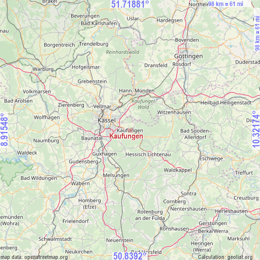
Kaufungen GPS coordinates[2]
51° 16' 51.996" North, 9° 37' 6.996" East
| Map corner | latitude | longitude |
|---|---|---|
| Upper-left | 51.71881°, | 8.91548° |
| Center: | 51.28111°, | 9.61861° |
| Lower-right: | 50.8392°, | 10.32174° |
| Map W x H: | 97.8×97.8 km | = 60.8×60.8mi |
| max Lat: | 55.01917° ⇑37.1% North |
| Kaufungen: | 51.28111° |
| min Lat: | ⇓62.9% South 47.40724° |
| min Long | Kaufungen | max Long |
| 5.92978° | 9.61861° | 14.98853° |
| W 44.2%⇐ | ⇒55.8% E |
Elevation
Elevation of Kaufungen is 212 m = 696 ft, and this is 37.1 m = 122 ft below average elevation for this country.
| Max E: |
1256 m = 4121 ft | 51.9% |
| Avg. | 249.1 m = 817 ft | |
| Kaufungen | 212 m = 696 ft | |
Min E: |
-5 m = -16 ft | 48.1% |
See also: Germany elevation on elevation.city.
Geographical zone
Kaufungen is located in North temperate zone (between Tropic of Cancer and the Arctic Circle). Distance of this North polar circle is 1699.2 km =1055.8 mi to North.| Distance of | km | miles | from Kaufungen |
|---|---|---|---|
| North Pole | 4305.1 | 2675.1 | to North |
| Arctic Circle | 1699.2 | 1055.8 | to North |
| Tropic Cancer | 3096 | 1923.8 | to South |
| Equator | 5701.9 | 3543 | to South |


Nearby cities:
15 places around Kaufungen: (largest is in red/bold)
• Baunatal
15 km =9.3 mi,  257°
257°
• Espenau
16.5 km =10.3 mi,  321°
321°
• Fuldabrück
9.5 km =5.9 mi, 260°
• Fuldatal
11.9 km =7.4 mi,  342°
342°
• Großalmerode
11.8 km =7.3 mi,  102°
102°
• Guxhagen
13 km =8.1 mi,  226°
226°
• Hannoversch Münden
15.1 km =9.4 mi,  8°
8°
• Helsa
5.4 km =3.4 mi,  115°
115°
• Hessisch Lichtenau
11.4 km =7.1 mi,  142°
142°
• Kassel
9.1 km =5.7 mi,  295°
295°
• Körle
14.6 km =9.1 mi,  209°
209°
• Lohfelden
6.1 km =3.8 mi,  254°
254°
• Melsungen
17.4 km =10.8 mi,  195°
195°
• Nieste
5.2 km =3.2 mi,  40°
40°
• Vellmar
12.9 km =8 mi,  311°
311°
Sources, notices
• [Note1] Compared only with cities in Germany existing in our database
• [Src1] Map data: © OpenStreetMap contributors (CC-BY-SA)
• [Src2] Other city data from geonames.org with taken over terms of usage.
• [Src3] Geographical zone / Annual Mean Temperature by Robert A. Rohde @ Wikipedia
