Großalmerode geodata
Großalmerode (Hesse) is a populated place; located in Germany in Europe/Berlin (GMT+2) time zone. With population of 7,393 people, there are 2093 cities with bigger population in this country. Compared to other cities in Germany, 62.5% of cities are located further ↓South; 53% of cities are located further →East and 72% of cities have lower elevation than Großalmerode. Note1
Administrative division(s):
- Level 1: Hesse
- Level 2: Regierungsbezirk Kassel
- Level 3: Werra-Meißner-Kreis
- Level 4: Großalmerode


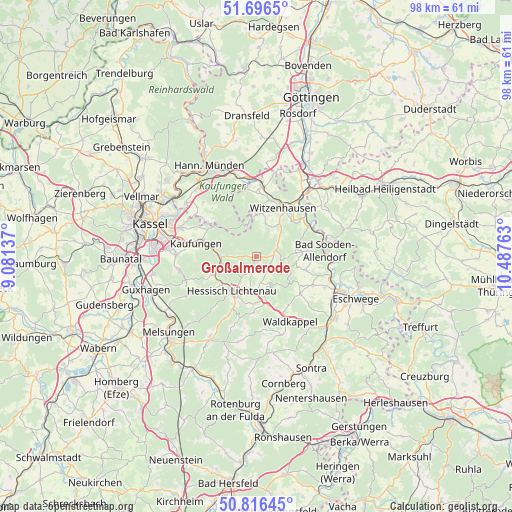
Großalmerode GPS coordinates[2]
51° 15' 30.888" North, 9° 47' 4.2" East
| Map corner | latitude | longitude |
|---|---|---|
| Upper-left | 51.6965°, | 9.08137° |
| Center: | 51.25858°, | 9.7845° |
| Lower-right: | 50.81645°, | 10.48763° |
| Map W x H: | 97.9×97.9 km | = 60.8×60.8mi |
| max Lat: | 55.01917° ⇑37.5% North |
| Großalmerode: | 51.25858° |
| min Lat: | ⇓62.5% South 47.40724° |
| min Long | Großalmerode | max Long |
| 5.92978° | 9.7845° | 14.98853° |
| W 47%⇐ | ⇒53% E |
Elevation
Elevation of Großalmerode is 374 m = 1227 ft, and this is 124.9 m = 410 ft above average elevation for this country.
| Max E: |
1256 m = 4121 ft | 28% |
| Großalmerode | 374 m 1227 ft | |
| Avg. | 249.1 m = 817 ft | |
Min E: |
-5 m = -16 ft | 72% |
See also: Germany elevation on elevation.city.
Geographical zone
Großalmerode is located in North temperate zone (between Tropic of Cancer and the Arctic Circle). Distance of this North polar circle is 1701.8 km =1057.4 mi to North.| Distance of | km | miles | from Großalmerode |
|---|---|---|---|
| North Pole | 4307.6 | 2676.6 | to North |
| Arctic Circle | 1701.8 | 1057.4 | to North |
| Tropic Cancer | 3093.5 | 1922.2 | to South |
| Equator | 5699.4 | 3541.4 | to South |


Nearby cities:
15 places around Großalmerode: (largest is in red/bold)
• Bad Sooden-Allendorf
13.3 km =8.3 mi,  84°
84°
• Bornhagen
14.2 km =8.8 mi,  54°
54°
• Fretterode
16.3 km =10.1 mi,  66°
66°
• Gerbershausen
16.1 km =10 mi,  58°
58°
• Helsa
6.7 km =4.2 mi,  271°
271°
• Hessisch Lichtenau
8 km =5 mi,  214°
214°
• Hohengandern
17.1 km =10.6 mi,  41°
41°
• Kaufungen
11.8 km =7.3 mi,  282°
282°
• Lindewerra
13.2 km =8.2 mi, 60°
• Lohfelden
17.5 km =10.9 mi, 272°
• Nieste
10.4 km =6.5 mi,  308°
308°
• Spangenberg
17.9 km =11.1 mi, 208°
• Wahlhausen
14.6 km =9.1 mi, 71°
• Waldkappel
14.2 km =8.8 mi,  153°
153°
• Witzenhausen
10.4 km =6.5 mi,  28°
28°
Sources, notices
• [Note1] Compared only with cities in Germany existing in our database
• [Src1] Map data: © OpenStreetMap contributors (CC-BY-SA)
• [Src2] Other city data from geonames.org with taken over terms of usage.
• [Src3] Geographical zone / Annual Mean Temperature by Robert A. Rohde @ Wikipedia
