Hessisch Lichtenau geodata
Hessisch Lichtenau (Hesse) is a populated place; located in Germany in Europe/Berlin (GMT+2) time zone. With population of 13,291 people, there are 1205 cities with bigger population in this country. Compared to other cities in Germany, 61.5% of cities are located further ↓South; 54% of cities are located further →East and 72.5% of cities have lower elevation than Hessisch Lichtenau. Note1
Administrative division(s):
- Level 1: Hesse
- Level 2: Regierungsbezirk Kassel
- Level 3: Werra-Meißner-Kreis
- Level 4: Hessisch Lichtenau


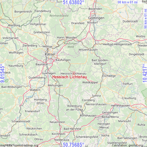
Hessisch Lichtenau GPS coordinates[2]
51° 11' 58.344" North, 9° 43' 6.852" East
| Map corner | latitude | longitude |
|---|---|---|
| Upper-left | 51.63802°, | 9.01545° |
| Center: | 51.19954°, | 9.71857° |
| Lower-right: | 50.75685°, | 10.4217° |
| Map W x H: | 98×98 km | = 60.9×60.9mi |
| max Lat: | 55.01917° ⇑38.5% North |
| Hessisch Lichtenau: | 51.19954° |
| min Lat: | ⇓61.5% South 47.40724° |
| min Long | Hessisch Lichte | max Long |
| 5.92978° | 9.71857° | 14.98853° |
| W 46%⇐ | ⇒54% E |
Elevation
Elevation of Hessisch Lichtenau is 378 m = 1240 ft, and this is 128.9 m = 423 ft above average elevation for this country.
| Max E: |
1256 m = 4121 ft | 27.5% |
| Hessisch Lichtenau | 378 m 1240 ft | |
| Avg. | 249.1 m = 817 ft | |
Min E: |
-5 m = -16 ft | 72.5% |
See also: Germany elevation on elevation.city.
Geographical zone
Hessisch Lichtenau is located in North temperate zone (between Tropic of Cancer and the Arctic Circle). Distance of this North polar circle is 1708.3 km =1061.5 mi to North.| Distance of | km | miles | from Hessisch Lichtenau |
|---|---|---|---|
| North Pole | 4314.2 | 2680.7 | to North |
| Arctic Circle | 1708.3 | 1061.5 | to North |
| Tropic Cancer | 3086.9 | 1918.1 | to South |
| Equator | 5692.9 | 3537.4 | to South |


Nearby cities:
15 places around Hessisch Lichtenau: (largest is in red/bold)
• Alheim
18.8 km =11.7 mi,  191°
191°
• Bad Sooden-Allendorf
19.5 km =12.1 mi,  66°
66°
• Fuldabrück
18 km =11.2 mi,  294°
294°
• Großalmerode
8 km =5 mi,  34°
34°
• Guxhagen
16.4 km =10.2 mi,  270°
270°
• Helsa
7 km =4.3 mi,  342°
342°
• Kaufungen
11.4 km =7.1 mi,  322°
322°
• Körle
14.5 km =9 mi,  255°
255°
• Lohfelden
14.9 km =9.3 mi,  300°
300°
• Malsfeld
17.4 km =10.8 mi,  226°
226°
• Melsungen
13.9 km =8.6 mi,  236°
236°
• Nieste
13.5 km =8.4 mi, 344°
• Spangenberg
10 km =6.2 mi,  202°
202°
• Waldkappel
12.6 km =7.8 mi,  118°
118°
• Witzenhausen
18.4 km =11.4 mi, 31°
Sources, notices
• [Note1] Compared only with cities in Germany existing in our database
• [Src1] Map data: © OpenStreetMap contributors (CC-BY-SA)
• [Src2] Other city data from geonames.org with taken over terms of usage.
• [Src3] Geographical zone / Annual Mean Temperature by Robert A. Rohde @ Wikipedia
