Niedersteinebach geodata
Niedersteinebach (Rheinland-Pfalz) is a seat of a fourth-order administrative division; located in Germany in Europe/Berlin (GMT+2) time zone. With population of 179 people, there are 10562 cities with bigger population in this country. Compared to other cities in Germany, 50.4% of cities are located further ↑North; 86.9% of cities are located further →East and 50.5% of cities have higher elevation than Niedersteinebach. Note1
Administrative division(s):
- Level 1: Rheinland-Pfalz
- Level 3: Landkreis Altenkirchen
- Level 4: Niedersteinebach


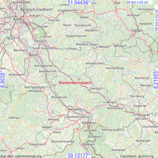
Niedersteinebach GPS coordinates[2]
50° 36' 0.648" North, 7° 30' 24.912" East
| Map corner | latitude | longitude |
|---|---|---|
| Upper-left | 51.04436°, | 6.8038° |
| Center: | 50.60018°, | 7.50692° |
| Lower-right: | 50.15177°, | 8.21005° |
| Map W x H: | 99.2×99.2 km | = 61.6×61.6mi |
| max Lat: | 55.01917° ⇑50.4% North |
| Niedersteinebach: | 50.60018° |
| min Lat: | ⇓49.6% South 47.40724° |
| min Long | Niedersteinebac | max Long |
| 5.92978° | 7.50692° | 14.98853° |
| W 13.1%⇐ | ⇒86.9% E |
Elevation
Elevation of Niedersteinebach is 221 m = 725 ft, and this is 28.1 m = 92 ft below average elevation for this country.
| Max E: |
1256 m = 4121 ft | 50.5% |
| Avg. | 249.1 m = 817 ft | |
| Niedersteinebach | 221 m = 725 ft | |
Min E: |
-5 m = -16 ft | 49.5% |
See also: Germany elevation on elevation.city.
Geographical zone
Niedersteinebach is located in North temperate zone (between Tropic of Cancer and the Arctic Circle). Distance of this North polar circle is 1775 km =1102.9 mi to North.| Distance of | km | miles | from Niedersteinebach |
|---|---|---|---|
| North Pole | 4380.8 | 2722.1 | to North |
| Arctic Circle | 1775 | 1102.9 | to North |
| Tropic Cancer | 3020.3 | 1876.7 | to South |
| Equator | 5626.2 | 3496 | to South |


Nearby cities:
15 places around Niedersteinebach: (largest is in red/bold)
• Burglahr
2.1 km =1.3 mi,  340°
340°
• Bürdenbach
0.8 km =0.5 mi,  54°
54°
• Döttesfeld
3.9 km =2.4 mi, 49°
• Eichen
4.1 km =2.5 mi,  26°
26°
• Eulenberg
2.3 km =1.4 mi,  286°
286°
• Güllesheim
1.5 km =0.9 mi,  99°
99°
• Horhausen
2.2 km =1.4 mi,  130°
130°
• Krunkel
1.9 km =1.2 mi,  194°
194°
• Linkenbach
3.6 km =2.2 mi,  121°
121°
• Oberlahr
2.6 km =1.6 mi,  15°
15°
• Obersteinebach
2.5 km =1.6 mi,  221°
221°
• Peterslahr
3.4 km =2.1 mi,  302°
302°
• Pleckhausen
2.6 km =1.6 mi, 102°
• Rott
3.7 km =2.3 mi,  10°
10°
• Willroth
3.7 km =2.3 mi,  157°
157°
Sources, notices
• [Note1] Compared only with cities in Germany existing in our database
• [Src1] Map data: © OpenStreetMap contributors (CC-BY-SA)
• [Src2] Other city data from geonames.org with taken over terms of usage.
• [Src3] Geographical zone / Annual Mean Temperature by Robert A. Rohde @ Wikipedia
