Niederorschel geodata
Niederorschel (Thuringia) is a seat of a fourth-order administrative division; located in Germany in Europe/Berlin (GMT+2) time zone. With population of 3,453 people, there are 3653 cities with bigger population in this country. Compared to other cities in Germany, 64.3% of cities are located further ↓South; 57.6% of cities are located further ←West and 57.9% of cities have lower elevation than Niederorschel. Note1


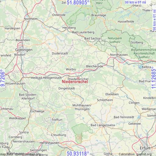
Niederorschel GPS coordinates[2]
51° 22' 19.992" North, 10° 25' 25.392" East
| Map corner | latitude | longitude |
|---|---|---|
| Upper-left | 51.80905°, | 9.7206° |
| Center: | 51.37222°, | 10.42372° |
| Lower-right: | 50.93118°, | 11.12685° |
| Map W x H: | 97.6×97.6 km | = 60.6×60.6mi |
| max Lat: | 55.01917° ⇑35.7% North |
| Niederorschel: | 51.37222° |
| min Lat: | ⇓64.3% South 47.40724° |
| min Long | Niederorschel | max Long |
| 5.92978° | 10.42372° | 14.98853° |
| W 57.6%⇐ | ⇒42.4% E |
Elevation
Elevation of Niederorschel is 278 m = 912 ft, and this is 28.9 m = 95 ft above average elevation for this country.
| Max E: |
1256 m = 4121 ft | 42.1% |
| Niederorschel | 278 m 912 ft | |
| Avg. | 249.1 m = 817 ft | |
Min E: |
-5 m = -16 ft | 57.9% |
See also: Germany elevation on elevation.city.
Geographical zone
Niederorschel is located in North temperate zone (between Tropic of Cancer and the Arctic Circle). Distance of this North polar circle is 1689.1 km =1049.6 mi to North.| Distance of | km | miles | from Niederorschel |
|---|---|---|---|
| North Pole | 4295 | 2668.8 | to North |
| Arctic Circle | 1689.1 | 1049.6 | to North |
| Tropic Cancer | 3106.1 | 1930 | to South |
| Equator | 5712.1 | 3549.3 | to South |


Nearby cities:
15 places around Niederorschel: (largest is in red/bold)
• Breitenworbis
4.5 km =2.8 mi,  3°
3°
• Buhla
6.8 km =4.2 mi,  5°
5°
• Deuna
4 km =2.5 mi,  119°
119°
• Gernrode
3.5 km =2.2 mi,  331°
331°
• Gerterode
4.3 km =2.7 mi,  73°
73°
• Hausen
4.1 km =2.5 mi,  287°
287°
• Haynrode
8.3 km =5.2 mi, 10°
• Kallmerode
8.9 km =5.5 mi,  253°
253°
• Kirchworbis
4.7 km =2.9 mi,  336°
336°
• Kleinbartloff
3.7 km =2.3 mi,  228°
228°
• Leinefelde-Worbis
7 km =4.3 mi,  284°
284°
• Rehungen
7 km =4.3 mi,  80°
80°
• Sollstedt
8.3 km =5.2 mi,  147°
147°
• Vollenborn
5.8 km =3.6 mi, 115°
• Worbis
6.8 km =4.2 mi,  321°
321°
Sources, notices
• [Note1] Compared only with cities in Germany existing in our database
• [Src1] Map data: © OpenStreetMap contributors (CC-BY-SA)
• [Src2] Other city data from geonames.org with taken over terms of usage.
• [Src3] Geographical zone / Annual Mean Temperature by Robert A. Rohde @ Wikipedia
