Leinefelde-Worbis geodata
Leinefelde-Worbis (Thuringia) is a populated place; located in Germany in Europe/Berlin (GMT+2) time zone. With population of 13,740 people, there are 1167 cities with bigger population in this country. Compared to other cities in Germany, 64.6% of cities are located further ↓South; 55.9% of cities are located further ←West and 67.4% of cities have lower elevation than Leinefelde-Worbis. Note1


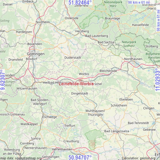
Leinefelde-Worbis GPS coordinates[2]
51° 23' 16.656" North, 10° 19' 34.32" East
| Map corner | latitude | longitude |
|---|---|---|
| Upper-left | 51.82464°, | 9.62307° |
| Center: | 51.38796°, | 10.3262° |
| Lower-right: | 50.94707°, | 11.02933° |
| Map W x H: | 97.6×97.6 km | = 60.6×60.6mi |
| max Lat: | 55.01917° ⇑35.4% North |
| Leinefelde-Worbis: | 51.38796° |
| min Lat: | ⇓64.6% South 47.40724° |
| min Long | Leinefelde-Worb | max Long |
| 5.92978° | 10.3262° | 14.98853° |
| W 55.9%⇐ | ⇒44.1% E |
Elevation
Elevation of Leinefelde-Worbis is 338 m = 1109 ft, and this is 88.9 m = 292 ft above average elevation for this country.
| Max E: |
1256 m = 4121 ft | 32.6% |
| Leinefelde-Worbis | 338 m 1109 ft | |
| Avg. | 249.1 m = 817 ft | |
Min E: |
-5 m = -16 ft | 67.4% |
See also: Germany elevation on elevation.city.
Geographical zone
Leinefelde-Worbis is located in North temperate zone (between Tropic of Cancer and the Arctic Circle). Distance of this North polar circle is 1687.4 km =1048.5 mi to North.| Distance of | km | miles | from Leinefelde-Worbis |
|---|---|---|---|
| North Pole | 4293.3 | 2667.7 | to North |
| Arctic Circle | 1687.4 | 1048.5 | to North |
| Tropic Cancer | 3107.9 | 1931.2 | to South |
| Equator | 5713.8 | 3550.4 | to South |


Nearby cities:
15 places around Leinefelde-Worbis: (largest is in red/bold)
• Breitenworbis
7.6 km =4.7 mi,  68°
68°
• Dingelstädt
8.1 km =5 mi,  184°
184°
• Ferna
7.1 km =4.4 mi,  345°
345°
• Gernrode
5.3 km =3.3 mi,  75°
75°
• Hausen
2.9 km =1.8 mi,  100°
100°
• Hundeshagen
5.9 km =3.7 mi,  329°
329°
• Kallmerode
4.6 km =2.9 mi,  203°
203°
• Kirchworbis
5.5 km =3.4 mi,  61°
61°
• Kleinbartloff
5.8 km =3.6 mi,  136°
136°
• Kreuzebra
6.8 km =4.2 mi,  231°
231°
• Niederorschel
7 km =4.3 mi, 104°
• Steinbach
8.4 km =5.2 mi,  296°
296°
• Wingerode
6 km =3.7 mi,  272°
272°
• Wintzingerode
6.2 km =3.9 mi,  5°
5°
• Worbis
4.4 km =2.7 mi,  35°
35°
Sources, notices
• [Note1] Compared only with cities in Germany existing in our database
• [Src1] Map data: © OpenStreetMap contributors (CC-BY-SA)
• [Src2] Other city data from geonames.org with taken over terms of usage.
• [Src3] Geographical zone / Annual Mean Temperature by Robert A. Rohde @ Wikipedia
