Worbis geodata
Worbis (Thuringia) is a populated place; located in Germany in Europe/Berlin (GMT+2) time zone. With population of 5,371 people, there are 2674 cities with bigger population in this country. Compared to other cities in Germany, 65.1% of cities are located further ↓South; 56.6% of cities are located further ←West and 65.4% of cities have lower elevation than Worbis. Note1


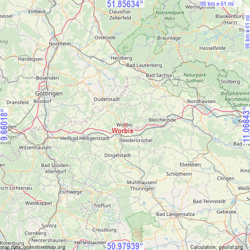
Worbis GPS coordinates[2]
51° 25' 11.892" North, 10° 21' 47.88" East
| Map corner | latitude | longitude |
|---|---|---|
| Upper-left | 51.85634°, | 9.66018° |
| Center: | 51.41997°, | 10.3633° |
| Lower-right: | 50.97939°, | 11.06643° |
| Map W x H: | 97.5×97.5 km | = 60.6×60.6mi |
| max Lat: | 55.01917° ⇑34.9% North |
| Worbis: | 51.41997° |
| min Lat: | ⇓65.1% South 47.40724° |
| min Long | Worbis | max Long |
| 5.92978° | 10.3633° | 14.98853° |
| W 56.6%⇐ | ⇒43.4% E |
Elevation
Elevation of Worbis is 324 m = 1063 ft, and this is 74.9 m = 246 ft above average elevation for this country.
| Max E: |
1256 m = 4121 ft | 34.6% |
| Worbis | 324 m 1063 ft | |
| Avg. | 249.1 m = 817 ft | |
Min E: |
-5 m = -16 ft | 65.4% |
See also: Germany elevation on elevation.city.
Geographical zone
Worbis is located in North temperate zone (between Tropic of Cancer and the Arctic Circle). Distance of this North polar circle is 1683.8 km =1046.3 mi to North.| Distance of | km | miles | from Worbis |
|---|---|---|---|
| North Pole | 4289.7 | 2665.5 | to North |
| Arctic Circle | 1683.8 | 1046.3 | to North |
| Tropic Cancer | 3111.4 | 1933.3 | to South |
| Equator | 5717.4 | 3552.6 | to South |


Nearby cities:
15 places around Worbis: (largest is in red/bold)
• Breitenworbis
4.6 km =2.9 mi,  100°
100°
• Buhla
5.1 km =3.2 mi,  72°
72°
• Ferna
5.5 km =3.4 mi,  307°
307°
• Gernrode
3.4 km =2.1 mi,  131°
131°
• Hausen
4.1 km =2.5 mi,  176°
176°
• Haynrode
6.4 km =4 mi,  63°
63°
• Holungen
8.2 km =5.1 mi,  14°
14°
• Hundeshagen
5.7 km =3.5 mi,  284°
284°
• Kirchworbis
2.5 km =1.6 mi,  113°
113°
• Kleinbartloff
7.9 km =4.9 mi,  169°
169°
• Leinefelde-Worbis
4.4 km =2.7 mi,  215°
215°
• Niederorschel
6.8 km =4.2 mi,  141°
141°
• Tastungen
6.6 km =4.1 mi,  325°
325°
• Wehnde
7.8 km =4.8 mi,  335°
335°
• Wintzingerode
3.3 km =2.1 mi,  322°
322°
Sources, notices
• [Note1] Compared only with cities in Germany existing in our database
• [Src1] Map data: © OpenStreetMap contributors (CC-BY-SA)
• [Src2] Other city data from geonames.org with taken over terms of usage.
• [Src3] Geographical zone / Annual Mean Temperature by Robert A. Rohde @ Wikipedia
