Hausen geodata
Hausen (Thuringia) is a seat of a fourth-order administrative division; located in Germany in Europe/Berlin (GMT+2) time zone. With population of 456 people, there are 9517 cities with bigger population in this country. Compared to other cities in Germany, 64.4% of cities are located further ↓South; 56.6% of cities are located further ←West and 67.2% of cities have lower elevation than Hausen. Note1


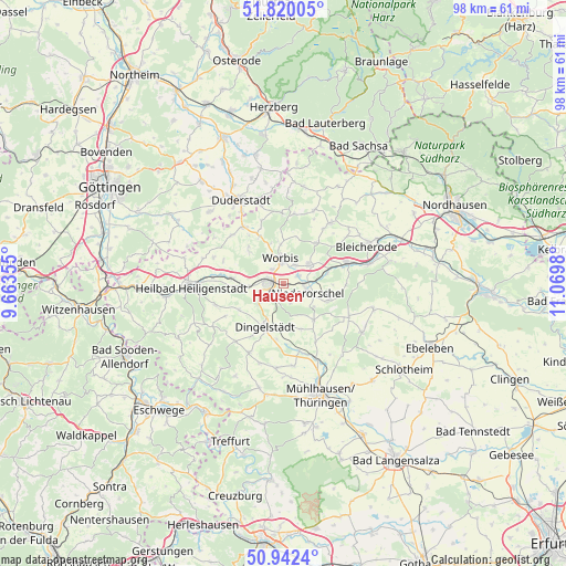
Hausen GPS coordinates[2]
51° 22' 59.988" North, 10° 22' 0.012" East
| Map corner | latitude | longitude |
|---|---|---|
| Upper-left | 51.82005°, | 9.66355° |
| Center: | 51.38333°, | 10.36667° |
| Lower-right: | 50.9424°, | 11.0698° |
| Map W x H: | 97.6×97.6 km | = 60.6×60.6mi |
| max Lat: | 55.01917° ⇑35.6% North |
| Hausen: | 51.38333° |
| min Lat: | ⇓64.4% South 47.40724° |
| min Long | Hausen | max Long |
| 5.92978° | 10.36667° | 14.98853° |
| W 56.6%⇐ | ⇒43.4% E |
Elevation
Elevation of Hausen is 337 m = 1106 ft, and this is 87.9 m = 288 ft above average elevation for this country.
| Max E: |
1256 m = 4121 ft | 32.8% |
| Hausen | 337 m 1106 ft | |
| Avg. | 249.1 m = 817 ft | |
Min E: |
-5 m = -16 ft | 67.2% |
See also: Germany elevation on elevation.city.
Geographical zone
Hausen is located in North temperate zone (between Tropic of Cancer and the Arctic Circle). Distance of this North polar circle is 1687.9 km =1048.8 mi to North.| Distance of | km | miles | from Hausen |
|---|---|---|---|
| North Pole | 4293.8 | 2668 | to North |
| Arctic Circle | 1687.9 | 1048.8 | to North |
| Tropic Cancer | 3107.4 | 1930.8 | to South |
| Equator | 5713.3 | 3550.1 | to South |


Nearby cities:
15 places around Hausen: (largest is in red/bold)
• Breitenworbis
5.4 km =3.4 mi,  52°
52°
• Buhla
7.2 km =4.5 mi,  39°
39°
• Deuna
8.1 km =5 mi,  113°
113°
• Dingelstädt
8.3 km =5.2 mi,  204°
204°
• Gernrode
3 km =1.9 mi, 51°
• Gerterode
8.1 km =5 mi,  90°
90°
• Hundeshagen
8 km =5 mi,  313°
313°
• Kallmerode
5.9 km =3.7 mi,  231°
231°
• Kirchworbis
3.7 km =2.3 mi,  33°
33°
• Kleinbartloff
3.9 km =2.4 mi,  162°
162°
• Leinefelde-Worbis
2.9 km =1.8 mi,  280°
280°
• Niederorschel
4.1 km =2.5 mi, 107°
• Silberhausen
8.3 km =5.2 mi,  193°
193°
• Wintzingerode
7 km =4.3 mi,  341°
341°
• Worbis
4.1 km =2.5 mi,  356°
356°
Sources, notices
• [Note1] Compared only with cities in Germany existing in our database
• [Src1] Map data: © OpenStreetMap contributors (CC-BY-SA)
• [Src2] Other city data from geonames.org with taken over terms of usage.
• [Src3] Geographical zone / Annual Mean Temperature by Robert A. Rohde @ Wikipedia
