Königsfeld geodata
Königsfeld (Rheinland-Pfalz) is a seat of a fourth-order administrative division; located in Germany in Europe/Berlin (GMT+2) time zone. With population of 623 people, there are 8698 cities with bigger population in this country. Compared to other cities in Germany, 52.9% of cities are located further ↑North; 91.6% of cities are located further →East and 52% of cities have lower elevation than Königsfeld. Note1
Administrative division(s):
- Level 1: Rheinland-Pfalz
- Level 3: Landkreis Ahrweiler
- Level 4: Königsfeld


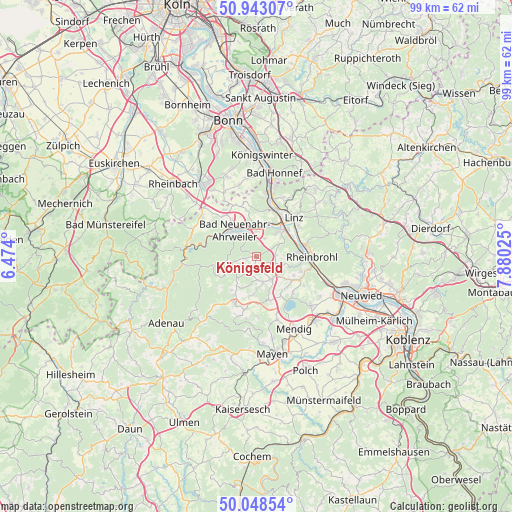
Königsfeld GPS coordinates[2]
50° 29' 52.512" North, 7° 10' 37.632" East
| Map corner | latitude | longitude |
|---|---|---|
| Upper-left | 50.94307°, | 6.474° |
| Center: | 50.49792°, | 7.17712° |
| Lower-right: | 50.04854°, | 7.88025° |
| Map W x H: | 99.5×99.5 km | = 61.8×61.8mi |
| max Lat: | 55.01917° ⇑52.9% North |
| Königsfeld: | 50.49792° |
| min Lat: | ⇓47.1% South 47.40724° |
| min Long | Königsfeld | max Long |
| 5.92978° | 7.17712° | 14.98853° |
| W 8.4%⇐ | ⇒91.6% E |
Elevation
Elevation of Königsfeld is 240 m = 787 ft, and this is 9.1 m = 30 ft below average elevation for this country.
| Max E: |
1256 m = 4121 ft | 48% |
| Avg. | 249.1 m = 817 ft | |
| Königsfeld | 240 m = 787 ft | |
Min E: |
-5 m = -16 ft | 52% |
See also: Germany elevation on elevation.city.
Geographical zone
Königsfeld is located in North temperate zone (between Tropic of Cancer and the Arctic Circle). Distance of this North polar circle is 1786.3 km =1110 mi to North.| Distance of | km | miles | from Königsfeld |
|---|---|---|---|
| North Pole | 4392.2 | 2729.2 | to North |
| Arctic Circle | 1786.3 | 1110 | to North |
| Tropic Cancer | 3008.9 | 1869.6 | to South |
| Equator | 5614.8 | 3488.9 | to South |


Nearby cities:
15 places around Königsfeld: (largest is in red/bold)
• Bad Breisig
7.9 km =4.9 mi,  84°
84°
• Bad Neuenahr-Ahrweiler
6.9 km =4.3 mi,  317°
317°
• Brenk
7.2 km =4.5 mi,  176°
176°
• Burgbrohl
8.6 km =5.3 mi,  124°
124°
• Dedenbach
1.7 km =1.1 mi,  164°
164°
• Galenberg
7.4 km =4.6 mi,  167°
167°
• Gönnersdorf
6.5 km =4 mi,  104°
104°
• Niederdürenbach
5.3 km =3.3 mi, 175°
• Niederzissen
5.2 km =3.2 mi,  146°
146°
• Oberdürenbach
3.6 km =2.2 mi,  192°
192°
• Oberzissen
5.6 km =3.5 mi, 163°
• Schalkenbach
2.2 km =1.4 mi,  261°
261°
• Sinzig
7.1 km =4.4 mi,  43°
43°
• Spessart
8 km =5 mi,  216°
216°
• Waldorf
4.3 km =2.7 mi,  112°
112°
Sources, notices
• [Note1] Compared only with cities in Germany existing in our database
• [Src1] Map data: © OpenStreetMap contributors (CC-BY-SA)
• [Src2] Other city data from geonames.org with taken over terms of usage.
• [Src3] Geographical zone / Annual Mean Temperature by Robert A. Rohde @ Wikipedia
