Neustadt geodata
Neustadt (Thuringia) is a populated place; located in Germany in Europe/Berlin (GMT+2) time zone. With population of 698 people, there are 8324 cities with bigger population in this country. Compared to other cities in Germany, 65.9% of cities are located further ↓South; 58.4% of cities are located further ←West and 63.1% of cities have lower elevation than Neustadt. Note1


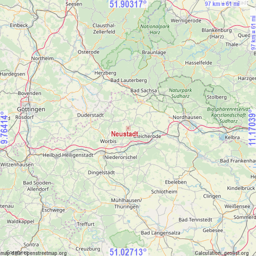
Neustadt GPS coordinates[2]
51° 28' 2.1" North, 10° 28' 2.136" East
| Map corner | latitude | longitude |
|---|---|---|
| Upper-left | 51.90317°, | 9.76414° |
| Center: | 51.46725°, | 10.46726° |
| Lower-right: | 51.02713°, | 11.17039° |
| Map W x H: | 97.4×97.4 km | = 60.5×60.5mi |
| max Lat: | 55.01917° ⇑34.1% North |
| Neustadt: | 51.46725° |
| min Lat: | ⇓65.9% South 47.40724° |
| min Long | Neustadt | max Long |
| 5.92978° | 10.46726° | 14.98853° |
| W 58.4%⇐ | ⇒41.6% E |
Elevation
Elevation of Neustadt is 309 m = 1014 ft, and this is 59.9 m = 197 ft above average elevation for this country.
| Max E: |
1256 m = 4121 ft | 36.9% |
| Neustadt | 309 m 1014 ft | |
| Avg. | 249.1 m = 817 ft | |
Min E: |
-5 m = -16 ft | 63.1% |
See also: Germany elevation on elevation.city.
Geographical zone
Neustadt is located in North temperate zone (between Tropic of Cancer and the Arctic Circle). Distance of this North polar circle is 1678.6 km =1043 mi to North.| Distance of | km | miles | from Neustadt |
|---|---|---|---|
| North Pole | 4284.4 | 2662.2 | to North |
| Arctic Circle | 1678.6 | 1043 | to North |
| Tropic Cancer | 3116.7 | 1936.6 | to South |
| Equator | 5722.6 | 3555.9 | to South |


Nearby cities:
15 places around Neustadt: (largest is in red/bold)
• Bischofferode
3.6 km =2.2 mi,  333°
333°
• Bleicherode
7.9 km =4.9 mi,  112°
112°
• Brehme
8.1 km =5 mi,  291°
291°
• Breitenworbis
6.6 km =4.1 mi,  204°
204°
• Buhla
4.4 km =2.7 mi,  211°
211°
• Großbodungen
1.3 km =0.8 mi,  45°
45°
• Haynrode
2.9 km =1.8 mi, 211°
• Holungen
5.8 km =3.6 mi,  297°
297°
• Kirchworbis
7.9 km =4.9 mi,  218°
218°
• Kleinbodungen
4.6 km =2.9 mi,  90°
90°
• Kraja
3.9 km =2.4 mi,  119°
119°
• Lipprechterode
6.1 km =3.8 mi,  100°
100°
• Sollstedt
7.3 km =4.5 mi,  140°
140°
• Steinrode
4.2 km =2.6 mi,  24°
24°
• Weißenborn-Lüderode
7.9 km =4.9 mi,  335°
335°
Sources, notices
• [Note1] Compared only with cities in Germany existing in our database
• [Src1] Map data: © OpenStreetMap contributors (CC-BY-SA)
• [Src2] Other city data from geonames.org with taken over terms of usage.
• [Src3] Geographical zone / Annual Mean Temperature by Robert A. Rohde @ Wikipedia
