Holungen geodata
Holungen (Thuringia) is a populated place; located in Germany in Europe/Berlin (GMT+2) time zone. With population of 960 people, there are 7310 cities with bigger population in this country. Compared to other cities in Germany, 66.2% of cities are located further ↓South; 57% of cities are located further ←West and 69% of cities have lower elevation than Holungen. Note1


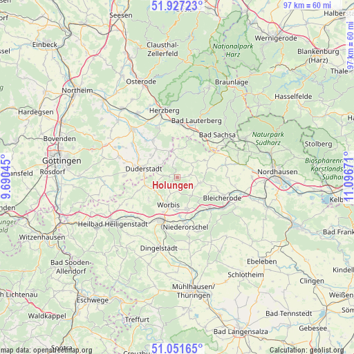
Holungen GPS coordinates[2]
51° 29' 29.544" North, 10° 23' 36.888" East
| Map corner | latitude | longitude |
|---|---|---|
| Upper-left | 51.92723°, | 9.69045° |
| Center: | 51.49154°, | 10.39358° |
| Lower-right: | 51.05165°, | 11.09671° |
| Map W x H: | 97.4×97.4 km | = 60.5×60.5mi |
| max Lat: | 55.01917° ⇑33.8% North |
| Holungen: | 51.49154° |
| min Lat: | ⇓66.2% South 47.40724° |
| min Long | Holungen | max Long |
| 5.92978° | 10.39358° | 14.98853° |
| W 57%⇐ | ⇒43% E |
Elevation
Elevation of Holungen is 351 m = 1152 ft, and this is 101.9 m = 334 ft above average elevation for this country.
| Max E: |
1256 m = 4121 ft | 31% |
| Holungen | 351 m 1152 ft | |
| Avg. | 249.1 m = 817 ft | |
Min E: |
-5 m = -16 ft | 69% |
See also: Germany elevation on elevation.city.
Geographical zone
Holungen is located in North temperate zone (between Tropic of Cancer and the Arctic Circle). Distance of this North polar circle is 1675.9 km =1041.4 mi to North.| Distance of | km | miles | from Holungen |
|---|---|---|---|
| North Pole | 4281.7 | 2660.5 | to North |
| Arctic Circle | 1675.9 | 1041.4 | to North |
| Tropic Cancer | 3119.4 | 1938.3 | to South |
| Equator | 5725.3 | 3557.5 | to South |


Nearby cities:
15 places around Holungen: (largest is in red/bold)
• Bischofferode
3.5 km =2.2 mi,  80°
80°
• Brehme
2.4 km =1.5 mi,  277°
277°
• Buhla
7 km =4.3 mi,  156°
156°
• Ecklingerode
5.4 km =3.4 mi, 280°
• Ferna
8 km =5 mi,  234°
234°
• Großbodungen
6.3 km =3.9 mi,  106°
106°
• Haynrode
6.3 km =3.9 mi,  144°
144°
• Jützenbach
3.9 km =2.4 mi,  345°
345°
• Neustadt
5.8 km =3.6 mi,  117°
117°
• Steinrode
6.9 km =4.3 mi, 80°
• Tastungen
6.3 km =3.9 mi,  246°
246°
• Wehnde
5.4 km =3.4 mi,  260°
260°
• Weißenborn-Lüderode
4.8 km =3 mi,  21°
21°
• Wintzingerode
6.8 km =4.2 mi,  217°
217°
• Worbis
8.2 km =5.1 mi,  194°
194°
Sources, notices
• [Note1] Compared only with cities in Germany existing in our database
• [Src1] Map data: © OpenStreetMap contributors (CC-BY-SA)
• [Src2] Other city data from geonames.org with taken over terms of usage.
• [Src3] Geographical zone / Annual Mean Temperature by Robert A. Rohde @ Wikipedia
