Steinrode geodata
Steinrode (Thuringia) is a populated place; located in Germany in Europe/Berlin (GMT+2) time zone. With population of 534 people, there are 9173 cities with bigger population in this country. Compared to other cities in Germany, 66.4% of cities are located further ↓South; 58.8% of cities are located further ←West and 60% of cities have lower elevation than Steinrode. Note1


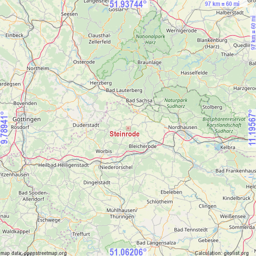
Steinrode GPS coordinates[2]
51° 30' 6.66" North, 10° 29' 33.144" East
| Map corner | latitude | longitude |
|---|---|---|
| Upper-left | 51.93744°, | 9.78941° |
| Center: | 51.50185°, | 10.49254° |
| Lower-right: | 51.06206°, | 11.19567° |
| Map W x H: | 97.3×97.3 km | = 60.5×60.5mi |
| max Lat: | 55.01917° ⇑33.6% North |
| Steinrode: | 51.50185° |
| min Lat: | ⇓66.4% South 47.40724° |
| min Long | Steinrode | max Long |
| 5.92978° | 10.49254° | 14.98853° |
| W 58.8%⇐ | ⇒41.2% E |
Elevation
Elevation of Steinrode is 290 m = 951 ft, and this is 40.9 m = 134 ft above average elevation for this country.
| Max E: |
1256 m = 4121 ft | 40% |
| Steinrode | 290 m 951 ft | |
| Avg. | 249.1 m = 817 ft | |
Min E: |
-5 m = -16 ft | 60% |
See also: Germany elevation on elevation.city.
Geographical zone
Steinrode is located in North temperate zone (between Tropic of Cancer and the Arctic Circle). Distance of this North polar circle is 1674.7 km =1040.6 mi to North.| Distance of | km | miles | from Steinrode |
|---|---|---|---|
| North Pole | 4280.6 | 2659.8 | to North |
| Arctic Circle | 1674.7 | 1040.6 | to North |
| Tropic Cancer | 3120.5 | 1939 | to South |
| Equator | 5726.5 | 3558.3 | to South |


Nearby cities:
15 places around Steinrode: (largest is in red/bold)
• Bischofferode
3.4 km =2.1 mi,  260°
260°
• Bleicherode
8.8 km =5.5 mi,  141°
141°
• Buhla
8.7 km =5.4 mi,  208°
208°
• Etzelsrode
8.6 km =5.3 mi,  91°
91°
• Friedrichsthal
6.6 km =4.1 mi,  108°
108°
• Großbodungen
3 km =1.9 mi,  195°
195°
• Haynrode
7.1 km =4.4 mi, 207°
• Holungen
6.9 km =4.3 mi, 260°
• Jützenbach
8.2 km =5.1 mi,  288°
288°
• Kehmstedt
8.8 km =5.5 mi, 111°
• Kleinbodungen
4.8 km =3 mi, 144°
• Kraja
6 km =3.7 mi,  163°
163°
• Lipprechterode
6.5 km =4 mi, 139°
• Neustadt
4.2 km =2.6 mi, 204°
• Weißenborn-Lüderode
6.1 km =3.8 mi,  303°
303°
Sources, notices
• [Note1] Compared only with cities in Germany existing in our database
• [Src1] Map data: © OpenStreetMap contributors (CC-BY-SA)
• [Src2] Other city data from geonames.org with taken over terms of usage.
• [Src3] Geographical zone / Annual Mean Temperature by Robert A. Rohde @ Wikipedia
