Rhede geodata
Rhede (Lower Saxony) is a populated place; located in Germany in Europe/Berlin (GMT+2) time zone. With population of 4,063 people, there are 3265 cities with bigger population in this country. Compared to other cities in Germany, 82.1% of cities are located further ↓South; 90.4% of cities are located further →East and 97.6% of cities have higher elevation than Rhede. Note1


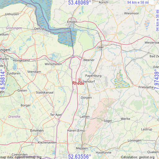
Rhede GPS coordinates[2]
53° 3' 36.72" North, 7° 16' 16.572" East
| Map corner | latitude | longitude |
|---|---|---|
| Upper-left | 53.48069°, | 6.56814° |
| Center: | 53.0602°, | 7.27127° |
| Lower-right: | 52.63556°, | 7.97439° |
| Map W x H: | 94×94 km | = 58.4×58.4mi |
| max Lat: | 55.01917° ⇑17.9% North |
| Rhede: | 53.0602° |
| min Lat: | ⇓82.1% South 47.40724° |
| min Long | Rhede | max Long |
| 5.92978° | 7.27127° | 14.98853° |
| W 9.6%⇐ | ⇒90.4% E |
Elevation
Elevation of Rhede is 3 m = 10 ft, and this is 246.1 m = 807 ft below average elevation for this country.
| Max E: |
1256 m = 4121 ft | 97.6% |
| Avg. | 249.1 m = 817 ft | |
| Rhede | 3 m = 10 ft | |
Min E: |
-5 m = -16 ft | 2.4% |
See also: Germany elevation on elevation.city.
Geographical zone
Rhede is located in North temperate zone (between Tropic of Cancer and the Arctic Circle). Distance of this North polar circle is 1501.4 km =932.9 mi to North.| Distance of | km | miles | from Rhede |
|---|---|---|---|
| North Pole | 4107.3 | 2552.2 | to North |
| Arctic Circle | 1501.4 | 932.9 | to North |
| Tropic Cancer | 3293.8 | 2046.7 | to South |
| Equator | 5899.7 | 3665.9 | to South |


Nearby cities:
15 places around Rhede: (largest is in red/bold)
• Bunde
13.7 km =8.5 mi,  358°
358°
• Dersum
11 km =6.8 mi,  179°
179°
• Dörpen
11.2 km =7 mi,  162°
162°
• Heede
7.8 km =4.8 mi,  166°
166°
• Kluse
14.5 km =9 mi, 161°
• Lehe
7.9 km =4.9 mi,  148°
148°
• Nenndorf
5.2 km =3.2 mi,  49°
49°
• Neubörger
16.4 km =10.2 mi,  133°
133°
• Neulehe
11.4 km =7.1 mi,  122°
122°
• Papenburg
9.1 km =5.7 mi,  77°
77°
• Surwold
18.7 km =11.6 mi, 119°
• Sustrum
16 km =9.9 mi, 177°
• Walchum
14.8 km =9.2 mi, 176°
• Weener
12.6 km =7.8 mi,  24°
24°
• Wippingen
17.7 km =11 mi, 149°
Sources, notices
• [Note1] Compared only with cities in Germany existing in our database
• [Src1] Map data: © OpenStreetMap contributors (CC-BY-SA)
• [Src2] Other city data from geonames.org with taken over terms of usage.
• [Src3] Geographical zone / Annual Mean Temperature by Robert A. Rohde @ Wikipedia
