Papenburg geodata
Papenburg (Lower Saxony) is a populated place; located in Germany in Europe/Berlin (GMT+2) time zone. With population of 34,117 people, there are 394 cities with bigger population in this country. Compared to other cities in Germany, 82.2% of cities are located further ↓South; 88.5% of cities are located further →East and 98.1% of cities have higher elevation than Papenburg. Note1


Papenburg GPS coordinates[2]
53° 4' 38.568" North, 7° 24' 15.984" East
| Map corner | latitude | longitude |
|---|---|---|
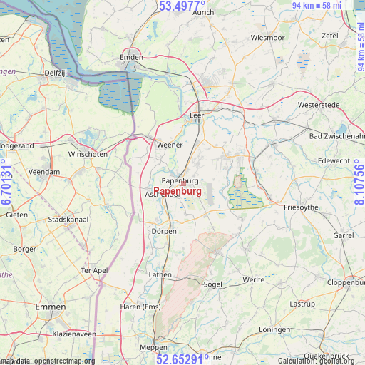
| Upper-left | 53.4977°, | 6.70131° |
| Center: | 53.07738°, | 7.40444° |
| Lower-right: | 52.65291°, | 8.10756° |
| Map W x H: | 93.9×93.9 km | = 58.3×58.3mi |
| max Lat: | 55.01917° ⇑17.8% North |
| Papenburg: | 53.07738° |
| min Lat: | ⇓82.2% South 47.40724° |
| min Long | Papenburg | max Long |
| 5.92978° | 7.40444° | 14.98853° |
| W 11.5%⇐ | ⇒88.5% E |
Elevation
Elevation of Papenburg is 2 m = 7 ft, and this is 247.1 m = 811 ft below average elevation for this country.
| Max E: |
1256 m = 4121 ft | 98.1% |
| Avg. | 249.1 m = 817 ft | |
| Papenburg | 2 m = 7 ft | |
Min E: |
-5 m = -16 ft | 1.9% |
See also: Germany elevation on elevation.city.
Geographical zone
Papenburg is located in North temperate zone (between Tropic of Cancer and the Arctic Circle). Distance of this North polar circle is 1499.5 km =931.7 mi to North.| Distance of | km | miles | from Papenburg |
|---|---|---|---|
| North Pole | 4105.4 | 2551 | to North |
| Arctic Circle | 1499.5 | 931.7 | to North |
| Tropic Cancer | 3295.7 | 2047.9 | to South |
| Equator | 5901.7 | 3667.1 | to South |


Nearby cities:
15 places around Papenburg: (largest is in red/bold)
• Bockhorst
12.5 km =7.8 mi,  113°
113°
• Bunde
14.9 km =9.3 mi,  322°
322°
• Dersum
15.6 km =9.7 mi,  214°
214°
• Dörpen
13.7 km =8.5 mi,  203°
203°
• Heede
11.8 km =7.3 mi,  216°
216°
• Kluse
16.2 km =10.1 mi, 195°
• Lehe
9.8 km =6.1 mi, 208°
• Nenndorf
5.2 km =3.2 mi,  286°
286°
• Neubörger
13.6 km =8.5 mi,  167°
167°
• Neulehe
8.1 km =5 mi,  175°
175°
• Ostrhauderfehn
15.5 km =9.6 mi,  66°
66°
• Rhede
9.1 km =5.7 mi,  257°
257°
• Surwold
13.3 km =8.3 mi,  146°
146°
• Weener
10.2 km =6.3 mi,  339°
339°
• Wippingen
17.1 km =10.6 mi, 179°
In other languages:
- In Spanish: Papenburgo
- In France: Papenbourg
- In Russian: Папенбург
- In Chinese: 帕彭堡
Sources, notices
• [Note1] Compared only with cities in Germany existing in our database
• [Src1] Map data: © OpenStreetMap contributors (CC-BY-SA)
• [Src2] Other city data from geonames.org with taken over terms of usage.
• [Src3] Geographical zone / Annual Mean Temperature by Robert A. Rohde @ Wikipedia
