Hörnum geodata
Hörnum (Schleswig-Holstein) is a populated place; located in Germany in Europe/Berlin (GMT+2) time zone. With population of 942 people, there are 7380 cities with bigger population in this country. Compared to other cities in Germany, 99.5% of cities are located further ↓South; 73% of cities are located further →East and 96.6% of cities have higher elevation than Hörnum. Note1
Administrative division(s):
- Level 1: Schleswig-Holstein
- Level 3: Kreis Nordfriesland
- Level 4: Hörnum (Sylt)


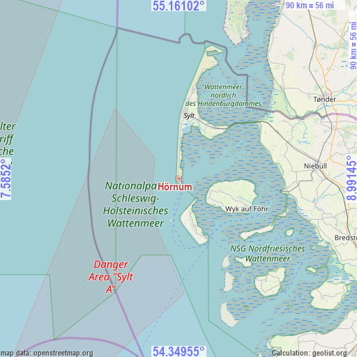
Hörnum GPS coordinates[2]
54° 45' 26.352" North, 8° 17' 17.988" East
| Map corner | latitude | longitude |
|---|---|---|
| Upper-left | 55.16102°, | 7.5852° |
| Center: | 54.75732°, | 8.28833° |
| Lower-right: | 54.34955°, | 8.99145° |
| Map W x H: | 90.2×90.2 km | = 56×56mi |
| max Lat: | 55.01917° ⇑0.5% North |
| Hörnum: | 54.75732° |
| min Lat: | ⇓99.5% South 47.40724° |
| min Long | Hörnum | max Long |
| 5.92978° | 8.28833° | 14.98853° |
| W 27%⇐ | ⇒73% E |
Elevation
Elevation of Hörnum is 5 m = 16 ft, and this is 244.1 m = 801 ft below average elevation for this country.
| Max E: |
1256 m = 4121 ft | 96.6% |
| Avg. | 249.1 m = 817 ft | |
| Hörnum | 5 m = 16 ft | |
Min E: |
-5 m = -16 ft | 3.4% |
See also: Germany elevation on elevation.city.
Geographical zone
Hörnum is located in North temperate zone (between Tropic of Cancer and the Arctic Circle). Distance of this North polar circle is 1312.7 km =815.7 mi to North.| Distance of | km | miles | from Hörnum |
|---|---|---|---|
| North Pole | 3918.6 | 2434.9 | to North |
| Arctic Circle | 1312.7 | 815.7 | to North |
| Tropic Cancer | 3482.5 | 2163.9 | to South |
| Equator | 6088.4 | 3783.2 | to South |


Nearby cities:
15 places around Hörnum: (largest is in red/bold)
• Alkersum
15.2 km =9.4 mi,  111°
111°
• Borgsum
12.6 km =7.8 mi,  120°
120°
• Dunsum
9.2 km =5.7 mi, 108°
• Keitum
16 km =9.9 mi,  19°
19°
• Midlum
15.7 km =9.8 mi, 107°
• Nebel
12.6 km =7.8 mi,  160°
160°
• Nieblum
14.9 km =9.3 mi, 119°
• Norddorf
9.1 km =5.7 mi, 161°
• Oldsum
10.5 km =6.5 mi, 106°
• Rantum
9.8 km =6.1 mi,  1°
1°
• Sylt-Ost
14 km =8.7 mi,  34°
34°
• Süderende
10.2 km =6.3 mi, 109°
• Utersum
8.9 km =5.5 mi, 122°
• Witsum
11.7 km =7.3 mi, 123°
• Wittdün
15.9 km =9.9 mi, 155°
Sources, notices
• [Note1] Compared only with cities in Germany existing in our database
• [Src1] Map data: © OpenStreetMap contributors (CC-BY-SA)
• [Src2] Other city data from geonames.org with taken over terms of usage.
• [Src3] Geographical zone / Annual Mean Temperature by Robert A. Rohde @ Wikipedia
