Müllheim geodata
Müllheim (Baden-Württemberg) is a populated place; located in Germany in Europe/Berlin (GMT+2) time zone. With population of 18,097 people, there are 874 cities with bigger population in this country. Compared to other cities in Germany, 97.6% of cities are located further ↑North; 84.4% of cities are located further →East and 56.3% of cities have lower elevation than Müllheim. Note1
Administrative division(s):
- Level 1: Baden-Württemberg
- Level 2: Freiburg Region
- Level 3: Landkreis Breisgau-Hochschwarzwald
- Level 4: Müllheim


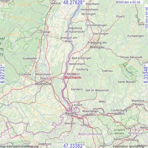
Müllheim GPS coordinates[2]
47° 48' 29.52" North, 7° 37' 49.26" East
| Map corner | latitude | longitude |
|---|---|---|
| Upper-left | 48.27828°, | 6.92723° |
| Center: | 47.8082°, | 7.63035° |
| Lower-right: | 47.33382°, | 8.33348° |
| Map W x H: | 105×105 km | = 65.2×65.2mi |
| max Lat: | 55.01917° ⇑97.6% North |
| Müllheim: | 47.8082° |
| min Lat: | ⇓2.4% South 47.40724° |
| min Long | Müllheim | max Long |
| 5.92978° | 7.63035° | 14.98853° |
| W 15.6%⇐ | ⇒84.4% E |
Elevation
Elevation of Müllheim is 268 m = 879 ft, and this is 18.9 m = 62 ft above average elevation for this country.
| Max E: |
1256 m = 4121 ft | 43.7% |
| Müllheim | 268 m 879 ft | |
| Avg. | 249.1 m = 817 ft | |
Min E: |
-5 m = -16 ft | 56.3% |
See also: Germany elevation on elevation.city.
Geographical zone
Müllheim is located in North temperate zone (between Tropic of Cancer and the Arctic Circle). Distance of this North polar circle is 2085.4 km =1295.8 mi to North.| Distance of | km | miles | from Müllheim |
|---|---|---|---|
| North Pole | 4691.3 | 2915 | to North |
| Arctic Circle | 2085.4 | 1295.8 | to North |
| Tropic Cancer | 2709.9 | 1683.9 | to South |
| Equator | 5315.8 | 3303.1 | to South |


Nearby cities:
15 places around Müllheim: (largest is in red/bold)
• Auggen
3.6 km =2.2 mi,  219°
219°
• Bad Bellingen
10.1 km =6.3 mi,  212°
212°
• Bad Krozingen
13.1 km =8.1 mi,  23°
23°
• Badenweiler
3.2 km =2 mi,  101°
101°
• Buggingen
4.4 km =2.7 mi,  7°
7°
• Eschbach
9.4 km =5.8 mi, 11°
• Feldberg
3.9 km =2.4 mi,  167°
167°
• Heitersheim
7.7 km =4.8 mi, 15°
• Kandern
10.8 km =6.7 mi, 167°
• Münstertal/Schwarzwald
12.6 km =7.8 mi,  65°
65°
• Neuenburg am Rhein
5.3 km =3.3 mi,  277°
277°
• Schliengen
7 km =4.3 mi, 215°
• Sulzburg
6.8 km =4.2 mi,  57°
57°
• Unterkrozingen
13.1 km =8.1 mi, 19°
• Wies
12.2 km =7.6 mi,  123°
123°
Sources, notices
• [Note1] Compared only with cities in Germany existing in our database
• [Src1] Map data: © OpenStreetMap contributors (CC-BY-SA)
• [Src2] Other city data from geonames.org with taken over terms of usage.
• [Src3] Geographical zone / Annual Mean Temperature by Robert A. Rohde @ Wikipedia
