Morschheim geodata
Morschheim (Rheinland-Pfalz) is a seat of a fourth-order administrative division; located in Germany in Europe/Berlin (GMT+2) time zone. With population of 756 people, there are 8067 cities with bigger population in this country. Compared to other cities in Germany, 71.5% of cities are located further ↑North; 76.7% of cities are located further →East and 62.9% of cities have lower elevation than Morschheim. Note1


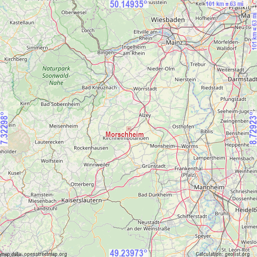
Morschheim GPS coordinates[2]
49° 41' 48.012" North, 8° 1' 33.996" East
| Map corner | latitude | longitude |
|---|---|---|
| Upper-left | 50.14935°, | 7.32298° |
| Center: | 49.69667°, | 8.02611° |
| Lower-right: | 49.23973°, | 8.72923° |
| Map W x H: | 101.1×101.1 km | = 62.8×62.8mi |
| max Lat: | 55.01917° ⇑71.5% North |
| Morschheim: | 49.69667° |
| min Lat: | ⇓28.5% South 47.40724° |
| min Long | Morschheim | max Long |
| 5.92978° | 8.02611° | 14.98853° |
| W 23.3%⇐ | ⇒76.7% E |
Elevation
Elevation of Morschheim is 308 m = 1010 ft, and this is 58.9 m = 193 ft above average elevation for this country.
| Max E: |
1256 m = 4121 ft | 37.1% |
| Morschheim | 308 m 1010 ft | |
| Avg. | 249.1 m = 817 ft | |
Min E: |
-5 m = -16 ft | 62.9% |
See also: Germany elevation on elevation.city.
Geographical zone
Morschheim is located in North temperate zone (between Tropic of Cancer and the Arctic Circle). Distance of this North polar circle is 1875.4 km =1165.3 mi to North.| Distance of | km | miles | from Morschheim |
|---|---|---|---|
| North Pole | 4481.3 | 2784.5 | to North |
| Arctic Circle | 1875.4 | 1165.3 | to North |
| Tropic Cancer | 2919.8 | 1814.3 | to South |
| Equator | 5525.8 | 3433.6 | to South |


Nearby cities:
15 places around Morschheim: (largest is in red/bold)
• Bechenheim
3.9 km =2.4 mi,  335°
335°
• Bischheim
3 km =1.9 mi,  171°
171°
• Freimersheim
4.7 km =2.9 mi,  74°
74°
• Gauersheim
5.3 km =3.3 mi,  141°
141°
• Ilbesheim
3.6 km =2.2 mi,  101°
101°
• Kirchheimbolanden
3.9 km =2.4 mi,  191°
191°
• Mauchenheim
2.8 km =1.7 mi,  31°
31°
• Nack
5.8 km =3.6 mi, 343°
• Nieder-Wiesen
5.1 km =3.2 mi,  322°
322°
• Oberwiesen
4.3 km =2.7 mi,  274°
274°
• Offenheim
3.2 km =2 mi,  5°
5°
• Orbis
1.9 km =1.2 mi,  281°
281°
• Rittersheim
4.2 km =2.6 mi,  146°
146°
• Stetten
5.6 km =3.5 mi,  122°
122°
• Wahlheim
6.2 km =3.9 mi, 67°
Sources, notices
• [Note1] Compared only with cities in Germany existing in our database
• [Src1] Map data: © OpenStreetMap contributors (CC-BY-SA)
• [Src2] Other city data from geonames.org with taken over terms of usage.
• [Src3] Geographical zone / Annual Mean Temperature by Robert A. Rohde @ Wikipedia
