Rittersheim geodata
Rittersheim (Rheinland-Pfalz) is a seat of a fourth-order administrative division; located in Germany in Europe/Berlin (GMT+2) time zone. With population of 202 people, there are 10463 cities with bigger population in this country. Compared to other cities in Germany, 72.2% of cities are located further ↑North; 76.1% of cities are located further →East and 51% of cities have higher elevation than Rittersheim. Note1


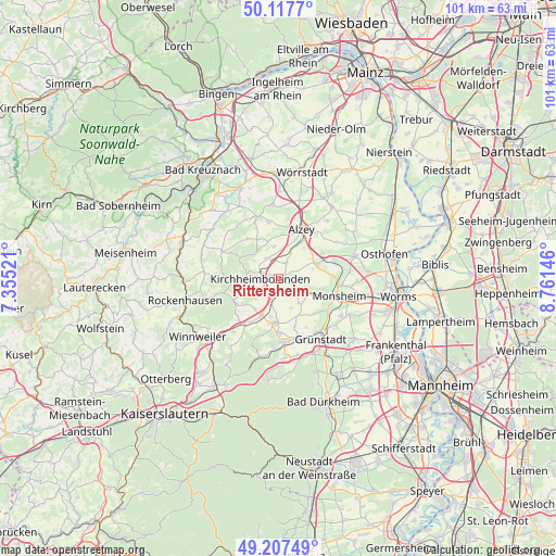
Rittersheim GPS coordinates[2]
49° 39' 52.992" North, 8° 3' 29.988" East
| Map corner | latitude | longitude |
|---|---|---|
| Upper-left | 50.1177°, | 7.35521° |
| Center: | 49.66472°, | 8.05833° |
| Lower-right: | 49.20749°, | 8.76146° |
| Map W x H: | 101.2×101.2 km | = 62.9×62.9mi |
| max Lat: | 55.01917° ⇑72.2% North |
| Rittersheim: | 49.66472° |
| min Lat: | ⇓27.8% South 47.40724° |
| min Long | Rittersheim | max Long |
| 5.92978° | 8.05833° | 14.98853° |
| W 23.9%⇐ | ⇒76.1% E |
Elevation
Elevation of Rittersheim is 218 m = 715 ft, and this is 31.1 m = 102 ft below average elevation for this country.
| Max E: |
1256 m = 4121 ft | 51% |
| Avg. | 249.1 m = 817 ft | |
| Rittersheim | 218 m = 715 ft | |
Min E: |
-5 m = -16 ft | 49% |
See also: Germany elevation on elevation.city.
Geographical zone
Rittersheim is located in North temperate zone (between Tropic of Cancer and the Arctic Circle). Distance of this North polar circle is 1879 km =1167.6 mi to North.| Distance of | km | miles | from Rittersheim |
|---|---|---|---|
| North Pole | 4484.9 | 2786.8 | to North |
| Arctic Circle | 1879 | 1167.6 | to North |
| Tropic Cancer | 2916.3 | 1812.1 | to South |
| Equator | 5522.2 | 3431.3 | to South |


Nearby cities:
15 places around Rittersheim: (largest is in red/bold)
• Albisheim
3.1 km =1.9 mi,  123°
123°
• Bischheim
1.9 km =1.2 mi,  287°
287°
• Bolanden
4.4 km =2.7 mi,  229°
229°
• Einselthum
5 km =3.1 mi,  106°
106°
• Freimersheim
5.3 km =3.3 mi,  24°
24°
• Gauersheim
1.1 km =0.7 mi, 119°
• Ilbesheim
3.1 km =1.9 mi, 23°
• Immesheim
4.6 km =2.9 mi,  132°
132°
• Kirchheimbolanden
3.1 km =1.9 mi,  265°
265°
• Marnheim
3.8 km =2.4 mi,  200°
200°
• Morschheim
4.2 km =2.6 mi,  326°
326°
• Orbis
5.7 km =3.5 mi,  313°
313°
• Ottersheim
5.7 km =3.5 mi,  140°
140°
• Rüssingen
5.8 km =3.6 mi,  158°
158°
• Stetten
2.5 km =1.6 mi,  77°
77°
Sources, notices
• [Note1] Compared only with cities in Germany existing in our database
• [Src1] Map data: © OpenStreetMap contributors (CC-BY-SA)
• [Src2] Other city data from geonames.org with taken over terms of usage.
• [Src3] Geographical zone / Annual Mean Temperature by Robert A. Rohde @ Wikipedia
