Bischheim geodata
Bischheim (Rheinland-Pfalz) is a seat of a fourth-order administrative division; located in Germany in Europe/Berlin (GMT+2) time zone. With population of 747 people, there are 8114 cities with bigger population in this country. Compared to other cities in Germany, 72% of cities are located further ↑North; 76.6% of cities are located further →East and 51.3% of cities have lower elevation than Bischheim. Note1


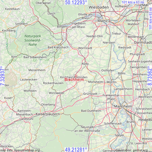
Bischheim GPS coordinates[2]
49° 40' 12" North, 8° 1' 57" East
| Map corner | latitude | longitude |
|---|---|---|
| Upper-left | 50.12293°, | 7.32937° |
| Center: | 49.67°, | 8.0325° |
| Lower-right: | 49.21281°, | 8.73562° |
| Map W x H: | 101.2×101.2 km | = 62.9×62.9mi |
| max Lat: | 55.01917° ⇑72% North |
| Bischheim: | 49.67° |
| min Lat: | ⇓28% South 47.40724° |
| min Long | Bischheim | max Long |
| 5.92978° | 8.0325° | 14.98853° |
| W 23.4%⇐ | ⇒76.6% E |
Elevation
Elevation of Bischheim is 235 m = 771 ft, and this is 14.1 m = 46 ft below average elevation for this country.
| Max E: |
1256 m = 4121 ft | 48.7% |
| Avg. | 249.1 m = 817 ft | |
| Bischheim | 235 m = 771 ft | |
Min E: |
-5 m = -16 ft | 51.3% |
See also: Germany elevation on elevation.city.
Geographical zone
Bischheim is located in North temperate zone (between Tropic of Cancer and the Arctic Circle). Distance of this North polar circle is 1878.4 km =1167.2 mi to North.| Distance of | km | miles | from Bischheim |
|---|---|---|---|
| North Pole | 4484.3 | 2786.4 | to North |
| Arctic Circle | 1878.4 | 1167.2 | to North |
| Tropic Cancer | 2916.9 | 1812.5 | to South |
| Equator | 5522.8 | 3431.7 | to South |


Nearby cities:
15 places around Bischheim: (largest is in red/bold)
• Albisheim
5 km =3.1 mi,  117°
117°
• Bolanden
3.7 km =2.3 mi,  203°
203°
• Freimersheim
5.9 km =3.7 mi,  43°
43°
• Gauersheim
3.1 km =1.9 mi,  111°
111°
• Ilbesheim
3.8 km =2.4 mi,  54°
54°
• Immesheim
6.4 km =4 mi,  125°
125°
• Kirchheimbolanden
1.5 km =0.9 mi,  236°
236°
• Marnheim
4.2 km =2.6 mi,  172°
172°
• Mauchenheim
5.4 km =3.4 mi,  10°
10°
• Morschheim
3 km =1.9 mi,  351°
351°
• Oberwiesen
5.8 km =3.6 mi,  305°
305°
• Offenheim
6.2 km =3.9 mi,  358°
358°
• Orbis
4.1 km =2.5 mi,  324°
324°
• Rittersheim
1.9 km =1.2 mi, 107°
• Stetten
4.3 km =2.7 mi,  90°
90°
Sources, notices
• [Note1] Compared only with cities in Germany existing in our database
• [Src1] Map data: © OpenStreetMap contributors (CC-BY-SA)
• [Src2] Other city data from geonames.org with taken over terms of usage.
• [Src3] Geographical zone / Annual Mean Temperature by Robert A. Rohde @ Wikipedia
