Einselthum geodata
Einselthum (Rheinland-Pfalz) is a seat of a fourth-order administrative division; located in Germany in Europe/Berlin (GMT+2) time zone. With population of 864 people, there are 7647 cities with bigger population in this country. Compared to other cities in Germany, 72.4% of cities are located further ↑North; 75% of cities are located further →East and 52.7% of cities have higher elevation than Einselthum. Note1


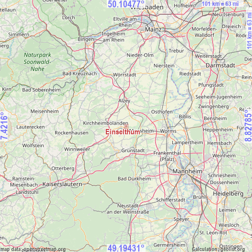
Einselthum GPS coordinates[2]
49° 39' 6.012" North, 8° 7' 28.992" East
| Map corner | latitude | longitude |
|---|---|---|
| Upper-left | 50.10477°, | 7.4216° |
| Center: | 49.65167°, | 8.12472° |
| Lower-right: | 49.19431°, | 8.82785° |
| Map W x H: | 101.2×101.2 km | = 62.9×62.9mi |
| max Lat: | 55.01917° ⇑72.4% North |
| Einselthum: | 49.65167° |
| min Lat: | ⇓27.6% South 47.40724° |
| min Long | Einselthum | max Long |
| 5.92978° | 8.12472° | 14.98853° |
| W 25%⇐ | ⇒75% E |
Elevation
Elevation of Einselthum is 206 m = 676 ft, and this is 43.1 m = 141 ft below average elevation for this country.
| Max E: |
1256 m = 4121 ft | 52.7% |
| Avg. | 249.1 m = 817 ft | |
| Einselthum | 206 m = 676 ft | |
Min E: |
-5 m = -16 ft | 47.3% |
See also: Germany elevation on elevation.city.
Geographical zone
Einselthum is located in North temperate zone (between Tropic of Cancer and the Arctic Circle). Distance of this North polar circle is 1880.4 km =1168.4 mi to North.| Distance of | km | miles | from Einselthum |
|---|---|---|---|
| North Pole | 4486.3 | 2787.7 | to North |
| Arctic Circle | 1880.4 | 1168.4 | to North |
| Tropic Cancer | 2914.8 | 1811.2 | to South |
| Equator | 5520.7 | 3430.4 | to South |


Nearby cities:
15 places around Einselthum: (largest is in red/bold)
• Albisheim
2.2 km =1.4 mi,  263°
263°
• Biedesheim
5.3 km =3.3 mi,  193°
193°
• Bubenheim
2.7 km =1.7 mi, 190°
• Flomborn
4.7 km =2.9 mi,  22°
22°
• Gauersheim
3.9 km =2.4 mi,  283°
283°
• Ilbesheim
5.6 km =3.5 mi,  320°
320°
• Immesheim
2.2 km =1.4 mi,  219°
219°
• Kindenheim
5.3 km =3.3 mi,  147°
147°
• Mölsheim
3.3 km =2.1 mi,  99°
99°
• Ober-Flörsheim
4.1 km =2.5 mi,  32°
32°
• Ottersheim
3.1 km =1.9 mi,  201°
201°
• Rittersheim
5 km =3.1 mi,  286°
286°
• Rüssingen
4.8 km =3 mi,  213°
213°
• Stetten
3.1 km =1.9 mi,  309°
309°
• Wachenheim
3.3 km =2.1 mi,  118°
118°
Sources, notices
• [Note1] Compared only with cities in Germany existing in our database
• [Src1] Map data: © OpenStreetMap contributors (CC-BY-SA)
• [Src2] Other city data from geonames.org with taken over terms of usage.
• [Src3] Geographical zone / Annual Mean Temperature by Robert A. Rohde @ Wikipedia
