Kindenheim geodata
Kindenheim (Rheinland-Pfalz) is a seat of a fourth-order administrative division; located in Germany in Europe/Berlin (GMT+2) time zone. With population of 1,028 people, there are 7083 cities with bigger population in this country. Compared to other cities in Germany, 73.5% of cities are located further ↑North; 74.6% of cities are located further →East and 50.2% of cities have higher elevation than Kindenheim. Note1
Administrative division(s):
- Level 1: Rheinland-Pfalz
- Level 3: Landkreis Bad Dürkheim
- Level 4: Kindenheim


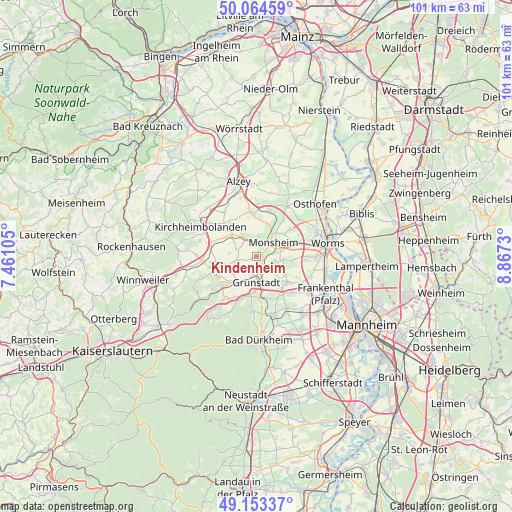
Kindenheim GPS coordinates[2]
49° 36' 39.996" North, 8° 9' 51.012" East
| Map corner | latitude | longitude |
|---|---|---|
| Upper-left | 50.06459°, | 7.46105° |
| Center: | 49.61111°, | 8.16417° |
| Lower-right: | 49.15337°, | 8.8673° |
| Map W x H: | 101.3×101.3 km | = 62.9×62.9mi |
| max Lat: | 55.01917° ⇑73.5% North |
| Kindenheim: | 49.61111° |
| min Lat: | ⇓26.5% South 47.40724° |
| min Long | Kindenheim | max Long |
| 5.92978° | 8.16417° | 14.98853° |
| W 25.4%⇐ | ⇒74.6% E |
Elevation
Elevation of Kindenheim is 224 m = 735 ft, and this is 25.1 m = 82 ft below average elevation for this country.
| Max E: |
1256 m = 4121 ft | 50.2% |
| Avg. | 249.1 m = 817 ft | |
| Kindenheim | 224 m = 735 ft | |
Min E: |
-5 m = -16 ft | 49.8% |
See also: Germany elevation on elevation.city.
Geographical zone
Kindenheim is located in North temperate zone (between Tropic of Cancer and the Arctic Circle). Distance of this North polar circle is 1884.9 km =1171.2 mi to North.| Distance of | km | miles | from Kindenheim |
|---|---|---|---|
| North Pole | 4490.8 | 2790.5 | to North |
| Arctic Circle | 1884.9 | 1171.2 | to North |
| Tropic Cancer | 2910.3 | 1808.4 | to South |
| Equator | 5516.2 | 3427.6 | to South |


Nearby cities:
15 places around Kindenheim: (largest is in red/bold)
• Biedesheim
4.2 km =2.6 mi,  260°
260°
• Bockenheim
1.6 km =1 mi,  108°
108°
• Bubenheim
3.8 km =2.4 mi,  299°
299°
• Einselthum
5.3 km =3.3 mi,  327°
327°
• Grünstadt
5.3 km =3.3 mi,  181°
181°
• Heidesheim
3.9 km =2.4 mi,  144°
144°
• Hohen-Sülzen
4.5 km =2.8 mi,  78°
78°
• Immesheim
5.1 km =3.2 mi, 303°
• Mertesheim
4.8 km =3 mi,  205°
205°
• Monsheim
4.5 km =2.8 mi,  49°
49°
• Mölsheim
4 km =2.5 mi,  5°
5°
• Obrigheim
3.6 km =2.2 mi,  126°
126°
• Ottersheim
4.3 km =2.7 mi,  291°
291°
• Quirnheim
4 km =2.5 mi,  222°
222°
• Wachenheim
2.9 km =1.8 mi,  1°
1°
Sources, notices
• [Note1] Compared only with cities in Germany existing in our database
• [Src1] Map data: © OpenStreetMap contributors (CC-BY-SA)
• [Src2] Other city data from geonames.org with taken over terms of usage.
• [Src3] Geographical zone / Annual Mean Temperature by Robert A. Rohde @ Wikipedia
