Molbergen geodata
Molbergen (Lower Saxony) is a seat of a fourth-order administrative division; located in Germany in Europe/Berlin (GMT+2) time zone. With population of 7,709 people, there are 2008 cities with bigger population in this country. Compared to other cities in Germany, 80.8% of cities are located further ↓South; 78.5% of cities are located further →East and 84.5% of cities have higher elevation than Molbergen. Note1


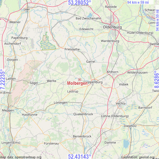
Molbergen GPS coordinates[2]
52° 51' 28.98" North, 7° 55' 31.728" East
| Map corner | latitude | longitude |
|---|---|---|
| Upper-left | 53.28052°, | 7.22235° |
| Center: | 52.85805°, | 7.92548° |
| Lower-right: | 52.43143°, | 8.6286° |
| Map W x H: | 94.4×94.4 km | = 58.7×58.7mi |
| max Lat: | 55.01917° ⇑19.2% North |
| Molbergen: | 52.85805° |
| min Lat: | ⇓80.8% South 47.40724° |
| min Long | Molbergen | max Long |
| 5.92978° | 7.92548° | 14.98853° |
| W 21.5%⇐ | ⇒78.5% E |
Elevation
Elevation of Molbergen is 36 m = 118 ft, and this is 213.1 m = 699 ft below average elevation for this country.
| Max E: |
1256 m = 4121 ft | 84.5% |
| Avg. | 249.1 m = 817 ft | |
| Molbergen | 36 m = 118 ft | |
Min E: |
-5 m = -16 ft | 15.5% |
See also: Germany elevation on elevation.city.
Geographical zone
Molbergen is located in North temperate zone (between Tropic of Cancer and the Arctic Circle). Distance of this North polar circle is 1523.9 km =946.9 mi to North.| Distance of | km | miles | from Molbergen |
|---|---|---|---|
| North Pole | 4129.8 | 2566.1 | to North |
| Arctic Circle | 1523.9 | 946.9 | to North |
| Tropic Cancer | 3271.3 | 2032.7 | to South |
| Equator | 5877.3 | 3652 | to South |


Nearby cities:
15 places around Molbergen: (largest is in red/bold)
• Bösel
15.9 km =9.9 mi,  5°
5°
• Bühren
20.5 km =12.7 mi,  106°
106°
• Cappeln
13.8 km =8.6 mi, 112°
• Cloppenburg
8.1 km =5 mi,  98°
98°
• Emstek
15.3 km =9.5 mi, 100°
• Essen
15.1 km =9.4 mi,  177°
177°
• Friesoythe
18.9 km =11.7 mi,  346°
346°
• Garrel
11.9 km =7.4 mi,  30°
30°
• Lastrup
8.1 km =5 mi,  209°
209°
• Lorup
20.3 km =12.6 mi,  291°
291°
• Löningen
17.6 km =10.9 mi,  219°
219°
• Quakenbrück
20.4 km =12.7 mi, 175°
• Rastdorf
15.8 km =9.8 mi, 292°
• Vrees
11 km =6.8 mi,  284°
284°
• Werlte
16.3 km =10.1 mi,  266°
266°
Sources, notices
• [Note1] Compared only with cities in Germany existing in our database
• [Src1] Map data: © OpenStreetMap contributors (CC-BY-SA)
• [Src2] Other city data from geonames.org with taken over terms of usage.
• [Src3] Geographical zone / Annual Mean Temperature by Robert A. Rohde @ Wikipedia
