Garrel geodata
Garrel (Lower Saxony) is a seat of a fourth-order administrative division; located in Germany in Europe/Berlin (GMT+2) time zone. With population of 12,273 people, there are 1331 cities with bigger population in this country. Compared to other cities in Germany, 81.4% of cities are located further ↓South; 76.8% of cities are located further →East and 90.5% of cities have higher elevation than Garrel. Note1


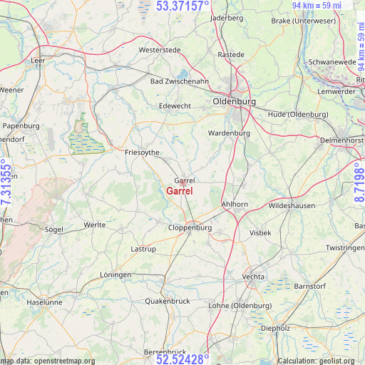
Garrel GPS coordinates[2]
52° 57' 0" North, 8° 1' 0.012" East
| Map corner | latitude | longitude |
|---|---|---|
| Upper-left | 53.37157°, | 7.31355° |
| Center: | 52.95°, | 8.01667° |
| Lower-right: | 52.52428°, | 8.7198° |
| Map W x H: | 94.2×94.2 km | = 58.5×58.5mi |
| max Lat: | 55.01917° ⇑18.6% North |
| Garrel: | 52.95° |
| min Lat: | ⇓81.4% South 47.40724° |
| min Long | Garrel | max Long |
| 5.92978° | 8.01667° | 14.98853° |
| W 23.2%⇐ | ⇒76.8% E |
Elevation
Elevation of Garrel is 20 m = 66 ft, and this is 229.1 m = 752 ft below average elevation for this country.
| Max E: |
1256 m = 4121 ft | 90.5% |
| Avg. | 249.1 m = 817 ft | |
| Garrel | 20 m = 66 ft | |
Min E: |
-5 m = -16 ft | 9.5% |
See also: Germany elevation on elevation.city.
Geographical zone
Garrel is located in North temperate zone (between Tropic of Cancer and the Arctic Circle). Distance of this North polar circle is 1513.7 km =940.6 mi to North.| Distance of | km | miles | from Garrel |
|---|---|---|---|
| North Pole | 4119.6 | 2559.8 | to North |
| Arctic Circle | 1513.7 | 940.6 | to North |
| Tropic Cancer | 3281.6 | 2039.1 | to South |
| Equator | 5887.5 | 3658.3 | to South |


Nearby cities:
15 places around Garrel: (largest is in red/bold)
• Bösel
7.1 km =4.4 mi,  321°
321°
• Bühren
21 km =13 mi,  139°
139°
• Cappeln
16.8 km =10.4 mi,  156°
156°
• Cloppenburg
11.5 km =7.1 mi,  170°
170°
• Edewecht
19.8 km =12.3 mi,  353°
353°
• Emstek
15.8 km =9.8 mi,  145°
145°
• Friesoythe
13.4 km =8.3 mi,  307°
307°
• Großenkneten
15.9 km =9.9 mi,  92°
92°
• Hilkenbrook
21.5 km =13.4 mi,  279°
279°
• Lastrup
20 km =12.4 mi,  210°
210°
• Molbergen
11.9 km =7.4 mi, 210°
• Rastdorf
21 km =13 mi,  258°
258°
• Visbek
23.9 km =14.9 mi,  122°
122°
• Vrees
18.3 km =11.4 mi,  246°
246°
• Wardenburg
17.9 km =11.1 mi,  43°
43°
Sources, notices
• [Note1] Compared only with cities in Germany existing in our database
• [Src1] Map data: © OpenStreetMap contributors (CC-BY-SA)
• [Src2] Other city data from geonames.org with taken over terms of usage.
• [Src3] Geographical zone / Annual Mean Temperature by Robert A. Rohde @ Wikipedia
