Erlangen geodata
Erlangen (Bavaria) is a seat of a third-order administrative division; located in Germany in Europe/Berlin (GMT+2) time zone. With population of 102,675 people, there are 95 cities with bigger population in this country. Compared to other cities in Germany, 74% of cities are located further ↑North; 67.1% of cities are located further ←West and 60% of cities have lower elevation than Erlangen. Note1
Administrative division(s):
- Level 1: Bavaria
- Level 2: Regierungsbezirk Mittelfranken
- Level 3: Kreisfreie Stadt Erlangen
- Level 4: Erlangen


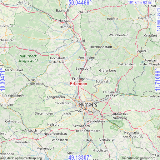
Erlangen GPS coordinates[2]
49° 35' 27.564" North, 11° 0' 28.188" East
| Map corner | latitude | longitude |
|---|---|---|
| Upper-left | 50.04466°, | 10.30471° |
| Center: | 49.59099°, | 11.00783° |
| Lower-right: | 49.13307°, | 11.71096° |
| Map W x H: | 101.4×101.4 km | = 63×63mi |
| max Lat: | 55.01917° ⇑74% North |
| Erlangen: | 49.59099° |
| min Lat: | ⇓26% South 47.40724° |
| min Long | Erlangen | max Long |
| 5.92978° | 11.00783° | 14.98853° |
| W 67.1%⇐ | ⇒32.9% E |
Elevation
Elevation of Erlangen is 290 m = 951 ft, and this is 40.9 m = 134 ft above average elevation for this country.
| Max E: |
1256 m = 4121 ft | 40% |
| Erlangen | 290 m 951 ft | |
| Avg. | 249.1 m = 817 ft | |
Min E: |
-5 m = -16 ft | 60% |
See also: Erlangen elevation on elevation.city.
Geographical zone
Erlangen is located in North temperate zone (between Tropic of Cancer and the Arctic Circle). Distance of this North polar circle is 1887.2 km =1172.7 mi to North.| Distance of | km | miles | from Erlangen |
|---|---|---|---|
| North Pole | 4493.1 | 2791.9 | to North |
| Arctic Circle | 1887.2 | 1172.7 | to North |
| Tropic Cancer | 2908.1 | 1807 | to South |
| Equator | 5514 | 3426.2 | to South |


Nearby cities:
15 places around Erlangen: (largest is in red/bold)
• Baiersdorf
7.7 km =4.8 mi,  15°
15°
• Bubenreuth
4.1 km =2.5 mi,  9°
9°
• Buckenhof
3.1 km =1.9 mi,  85°
85°
• Dormitz
8 km =5 mi,  84°
84°
• Effeltrich
9.8 km =6.1 mi,  38°
38°
• Herzogenaurach
9.2 km =5.7 mi,  253°
253°
• Heßdorf
8.1 km =5 mi,  299°
299°
• Kalchreuth
9.8 km =6.1 mi,  112°
112°
• Langensendelbach
7.1 km =4.4 mi, 39°
• Marloffstein
5 km =3.1 mi,  53°
53°
• Möhrendorf
4.7 km =2.9 mi,  353°
353°
• Neunkirchen am Brand
9.1 km =5.7 mi, 75°
• Poxdorf
9.2 km =5.7 mi,  29°
29°
• Spardorf
4 km =2.5 mi,  60°
60°
• Uttenreuth
4.7 km =2.9 mi, 82°
Sources, notices
• [Note1] Compared only with cities in Germany existing in our database
• [Src1] Map data: © OpenStreetMap contributors (CC-BY-SA)
• [Src2] Other city data from geonames.org with taken over terms of usage.
• [Src3] Geographical zone / Annual Mean Temperature by Robert A. Rohde @ Wikipedia
