Neuhaus-Schierschnitz geodata
Neuhaus-Schierschnitz (Thuringia) is a seat of a fourth-order administrative division; located in Germany in Europe/Berlin (GMT+2) time zone. With population of 3,460 people, there are 3645 cities with bigger population in this country. Compared to other cities in Germany, 56.5% of cities are located further ↑North; 70.5% of cities are located further ←West and 67.1% of cities have lower elevation than Neuhaus-Schierschnitz. Note1


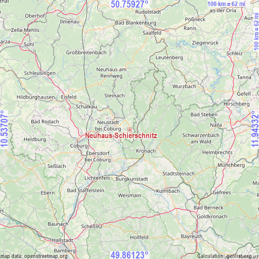
Neuhaus-Schierschnitz GPS coordinates[2]
50° 18' 44.532" North, 11° 14' 24.684" East
| Map corner | latitude | longitude |
|---|---|---|
| Upper-left | 50.75927°, | 10.53707° |
| Center: | 50.31237°, | 11.24019° |
| Lower-right: | 49.86123°, | 11.94332° |
| Map W x H: | 99.9×99.9 km | = 62.1×62.1mi |
| max Lat: | 55.01917° ⇑56.5% North |
| Neuhaus-Schierschnitz: | 50.31237° |
| min Lat: | ⇓43.5% South 47.40724° |
| min Long | Neuhaus-Schiers | max Long |
| 5.92978° | 11.24019° | 14.98853° |
| W 70.5%⇐ | ⇒29.5% E |
Elevation
Elevation of Neuhaus-Schierschnitz is 336 m = 1102 ft, and this is 86.9 m = 285 ft above average elevation for this country.
| Max E: |
1256 m = 4121 ft | 32.9% |
| Neuhaus-Schierschnitz | 336 m 1102 ft | |
| Avg. | 249.1 m = 817 ft | |
Min E: |
-5 m = -16 ft | 67.1% |
See also: Germany elevation on elevation.city.
Geographical zone
Neuhaus-Schierschnitz is located in North temperate zone (between Tropic of Cancer and the Arctic Circle). Distance of this North polar circle is 1807 km =1122.8 mi to North.| Distance of | km | miles | from Neuhaus-Schierschnitz |
|---|---|---|---|
| North Pole | 4412.9 | 2742 | to North |
| Arctic Circle | 1807 | 1122.8 | to North |
| Tropic Cancer | 2988.3 | 1856.8 | to South |
| Equator | 5594.2 | 3476.1 | to South |


Nearby cities:
15 places around Neuhaus-Schierschnitz: (largest is in red/bold)
• Ebersdorf
6.5 km =4 mi,  286°
286°
• Föritz
3.3 km =2.1 mi,  349°
349°
• Judenbach
9.4 km =5.8 mi, 351°
• Kronach
10.4 km =6.5 mi,  140°
140°
• Kueps Oberfranken
13.6 km =8.5 mi,  169°
169°
• Marktrodach
12.3 km =7.6 mi,  124°
124°
• Mengersgereuth-Hämmern
12.9 km =8 mi,  317°
317°
• Mitwitz
7.2 km =4.5 mi,  198°
198°
• Neustadt bei Coburg
8.7 km =5.4 mi,  282°
282°
• Pressig
6.6 km =4.1 mi,  47°
47°
• Schneckenlohe
11.7 km =7.3 mi, 196°
• Sonneberg
7 km =4.3 mi, 318°
• Sonnefeld
13.1 km =8.1 mi,  215°
215°
• Stockheim
3 km =1.9 mi,  102°
102°
• Wilhelmsthal
9.4 km =5.8 mi,  90°
90°
Sources, notices
• [Note1] Compared only with cities in Germany existing in our database
• [Src1] Map data: © OpenStreetMap contributors (CC-BY-SA)
• [Src2] Other city data from geonames.org with taken over terms of usage.
• [Src3] Geographical zone / Annual Mean Temperature by Robert A. Rohde @ Wikipedia
