Föritz geodata
Föritz (Thuringia) is a populated place; located in Germany in Europe/Berlin (GMT+2) time zone. With population of 3,693 people, there are 3481 cities with bigger population in this country. Compared to other cities in Germany, 55.8% of cities are located further ↑North; 70.4% of cities are located further ←West and 76.8% of cities have lower elevation than Föritz. Note1


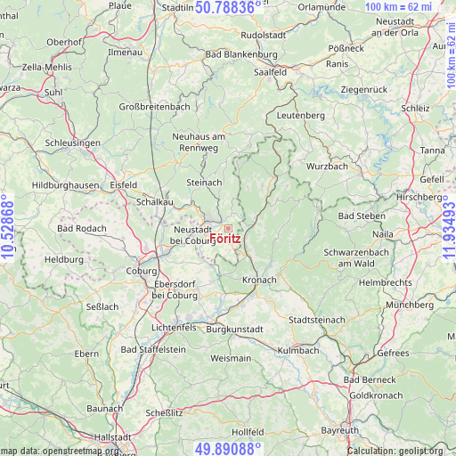
Föritz GPS coordinates[2]
50° 20' 30.264" North, 11° 13' 54.48" East
| Map corner | latitude | longitude |
|---|---|---|
| Upper-left | 50.78836°, | 10.52868° |
| Center: | 50.34174°, | 11.2318° |
| Lower-right: | 49.89088°, | 11.93493° |
| Map W x H: | 99.8×99.8 km | = 62×62mi |
| max Lat: | 55.01917° ⇑55.8% North |
| Föritz: | 50.34174° |
| min Lat: | ⇓44.2% South 47.40724° |
| min Long | Föritz | max Long |
| 5.92978° | 11.2318° | 14.98853° |
| W 70.4%⇐ | ⇒29.6% E |
Elevation
Elevation of Föritz is 411 m = 1348 ft, and this is 161.9 m = 531 ft above average elevation for this country.
| Max E: |
1256 m = 4121 ft | 23.2% |
| Föritz | 411 m 1348 ft | |
| Avg. | 249.1 m = 817 ft | |
Min E: |
-5 m = -16 ft | 76.8% |
See also: Germany elevation on elevation.city.
Geographical zone
Föritz is located in North temperate zone (between Tropic of Cancer and the Arctic Circle). Distance of this North polar circle is 1803.7 km =1120.8 mi to North.| Distance of | km | miles | from Föritz |
|---|---|---|---|
| North Pole | 4409.6 | 2740 | to North |
| Arctic Circle | 1803.7 | 1120.8 | to North |
| Tropic Cancer | 2991.6 | 1858.9 | to South |
| Equator | 5597.5 | 3478.1 | to South |


Nearby cities:
15 places around Föritz: (largest is in red/bold)
• Ebersdorf
5.8 km =3.6 mi,  255°
255°
• Judenbach
6.1 km =3.8 mi,  352°
352°
• Kronach
13.4 km =8.3 mi,  147°
147°
• Mengersgereuth-Hämmern
10.2 km =6.3 mi,  307°
307°
• Mitwitz
10.2 km =6.3 mi,  189°
189°
• Neuhaus-Schierschnitz
3.3 km =2.1 mi,  169°
169°
• Neustadt bei Coburg
8 km =5 mi, 260°
• Pressig
5.7 km =3.5 mi,  77°
77°
• Rödental
14.5 km =9 mi,  249°
249°
• Sonneberg
4.5 km =2.8 mi,  295°
295°
• Steinach
11.2 km =7 mi,  332°
332°
• Stockheim
5.3 km =3.3 mi,  137°
137°
• Tettau
14.4 km =8.9 mi,  7°
7°
• Teuschnitz
12.4 km =7.7 mi,  59°
59°
• Wilhelmsthal
10.6 km =6.6 mi,  108°
108°
Sources, notices
• [Note1] Compared only with cities in Germany existing in our database
• [Src1] Map data: © OpenStreetMap contributors (CC-BY-SA)
• [Src2] Other city data from geonames.org with taken over terms of usage.
• [Src3] Geographical zone / Annual Mean Temperature by Robert A. Rohde @ Wikipedia
