Micheln geodata
Micheln (Saxony-Anhalt) is a populated place; located in Germany in Europe/Berlin (GMT+2) time zone. With population of 791 people, there are 7937 cities with bigger population in this country. Compared to other cities in Germany, 70% of cities are located further ↓South; 81.4% of cities are located further ←West and 73.8% of cities have higher elevation than Micheln. Note1
Administrative division(s):
- Level 1: Saxony-Anhalt
- Level 3: Anhalt-Bitterfeld
- Level 4: Osternienburger Land


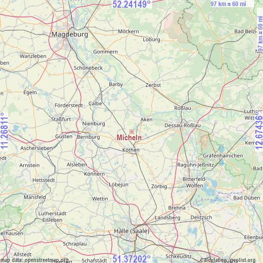
Micheln GPS coordinates[2]
51° 48' 31.86" North, 11° 58' 16.428" East
| Map corner | latitude | longitude |
|---|---|---|
| Upper-left | 52.24149°, | 11.26811° |
| Center: | 51.80885°, | 11.97123° |
| Lower-right: | 51.37202°, | 12.67436° |
| Map W x H: | 96.7×96.7 km | = 60.1×60.1mi |
| max Lat: | 55.01917° ⇑30% North |
| Micheln: | 51.80885° |
| min Lat: | ⇓70% South 47.40724° |
| min Long | Micheln | max Long |
| 5.92978° | 11.97123° | 14.98853° |
| W 81.4%⇐ | ⇒18.6% E |
Elevation
Elevation of Micheln is 68 m = 223 ft, and this is 181.1 m = 594 ft below average elevation for this country.
| Max E: |
1256 m = 4121 ft | 73.8% |
| Avg. | 249.1 m = 817 ft | |
| Micheln | 68 m = 223 ft | |
Min E: |
-5 m = -16 ft | 26.2% |
See also: Germany elevation on elevation.city.
Geographical zone
Micheln is located in North temperate zone (between Tropic of Cancer and the Arctic Circle). Distance of this North polar circle is 1640.6 km =1019.4 mi to North.| Distance of | km | miles | from Micheln |
|---|---|---|---|
| North Pole | 4246.5 | 2638.7 | to North |
| Arctic Circle | 1640.6 | 1019.4 | to North |
| Tropic Cancer | 3154.7 | 1960.2 | to South |
| Equator | 5760.6 | 3579.5 | to South |


Nearby cities:
15 places around Micheln: (largest is in red/bold)
• Aken
7 km =4.3 mi,  45°
45°
• Biendorf
10.6 km =6.6 mi,  232°
232°
• Drosa
4.6 km =2.9 mi,  280°
280°
• Elsnigk
6.2 km =3.9 mi,  108°
108°
• Gerbitz
10.7 km =6.6 mi,  290°
290°
• Großbadegast
9.4 km =5.8 mi,  156°
156°
• Großpaschleben
5.9 km =3.7 mi,  206°
206°
• Kleinpaschleben
6.6 km =4.1 mi,  245°
245°
• Köthen
6.3 km =3.9 mi,  180°
180°
• Osternienburg
4.1 km =2.5 mi, 113°
• Osternienburger Land
3.3 km =2.1 mi, 107°
• Steutz
10.6 km =6.6 mi,  43°
43°
• Wohlsdorf
8.8 km =5.5 mi,  235°
235°
• Wulfen
3 km =1.9 mi, 292°
• Zabitz
4.2 km =2.6 mi, 230°
Sources, notices
• [Note1] Compared only with cities in Germany existing in our database
• [Src1] Map data: © OpenStreetMap contributors (CC-BY-SA)
• [Src2] Other city data from geonames.org with taken over terms of usage.
• [Src3] Geographical zone / Annual Mean Temperature by Robert A. Rohde @ Wikipedia
