Zabitz geodata
Zabitz (Saxony-Anhalt) is a populated place; located in Germany in Europe/Berlin (GMT+2) time zone. With population of 549 people, there are 9085 cities with bigger population in this country. Compared to other cities in Germany, 69.8% of cities are located further ↓South; 80.6% of cities are located further ←West and 73.2% of cities have higher elevation than Zabitz. Note1
Administrative division(s):
- Level 1: Saxony-Anhalt
- Level 3: Anhalt-Bitterfeld
- Level 4: Osternienburger Land


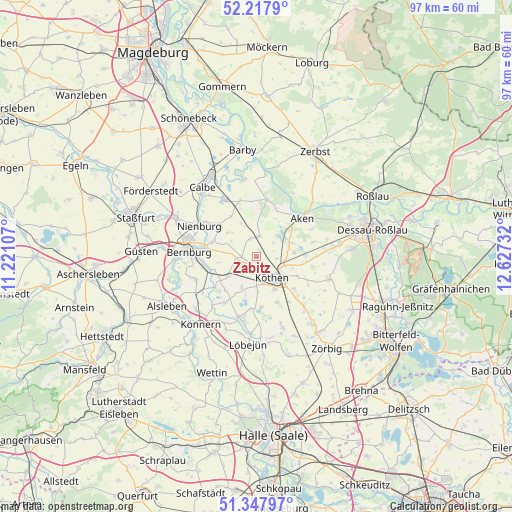
Zabitz GPS coordinates[2]
51° 47' 6.108" North, 11° 55' 27.084" East
| Map corner | latitude | longitude |
|---|---|---|
| Upper-left | 52.2179°, | 11.22107° |
| Center: | 51.78503°, | 11.92419° |
| Lower-right: | 51.34797°, | 12.62732° |
| Map W x H: | 96.7×96.7 km | = 60.1×60.1mi |
| max Lat: | 55.01917° ⇑30.2% North |
| Zabitz: | 51.78503° |
| min Lat: | ⇓69.8% South 47.40724° |
| min Long | Zabitz | max Long |
| 5.92978° | 11.92419° | 14.98853° |
| W 80.6%⇐ | ⇒19.4% E |
Elevation
Elevation of Zabitz is 71 m = 233 ft, and this is 178.1 m = 584 ft below average elevation for this country.
| Max E: |
1256 m = 4121 ft | 73.2% |
| Avg. | 249.1 m = 817 ft | |
| Zabitz | 71 m = 233 ft | |
Min E: |
-5 m = -16 ft | 26.8% |
See also: Germany elevation on elevation.city.
Geographical zone
Zabitz is located in North temperate zone (between Tropic of Cancer and the Arctic Circle). Distance of this North polar circle is 1643.2 km =1021 mi to North.| Distance of | km | miles | from Zabitz |
|---|---|---|---|
| North Pole | 4249.1 | 2640.3 | to North |
| Arctic Circle | 1643.2 | 1021 | to North |
| Tropic Cancer | 3152 | 1958.6 | to South |
| Equator | 5758 | 3577.9 | to South |


Nearby cities:
15 places around Zabitz: (largest is in red/bold)
• Baalberge
8.9 km =5.5 mi,  255°
255°
• Biendorf
6.5 km =4 mi,  233°
233°
• Cörmigk
8.6 km =5.3 mi,  221°
221°
• Drosa
3.7 km =2.3 mi,  339°
339°
• Elsnigk
9.2 km =5.7 mi,  85°
85°
• Großpaschleben
2.7 km =1.7 mi,  167°
167°
• Kleinpaschleben
2.7 km =1.7 mi,  267°
267°
• Köthen
4.9 km =3 mi,  138°
138°
• Latdorf
8.9 km =5.5 mi,  287°
287°
• Micheln
4.2 km =2.6 mi,  50°
50°
• Osternienburg
7.1 km =4.4 mi,  82°
82°
• Osternienburger Land
6.6 km =4.1 mi, 75°
• Poley
7.2 km =4.5 mi, 261°
• Wohlsdorf
4.6 km =2.9 mi,  240°
240°
• Wulfen
3.8 km =2.4 mi,  6°
6°
Sources, notices
• [Note1] Compared only with cities in Germany existing in our database
• [Src1] Map data: © OpenStreetMap contributors (CC-BY-SA)
• [Src2] Other city data from geonames.org with taken over terms of usage.
• [Src3] Geographical zone / Annual Mean Temperature by Robert A. Rohde @ Wikipedia
