Wulfen geodata
Wulfen (Saxony-Anhalt) is a populated place; located in Germany in Europe/Berlin (GMT+2) time zone. With population of 1,215 people, there are 6522 cities with bigger population in this country. Compared to other cities in Germany, 70.1% of cities are located further ↓South; 80.8% of cities are located further ←West and 73.6% of cities have higher elevation than Wulfen. Note1
Administrative division(s):
- Level 1: Saxony-Anhalt
- Level 3: Anhalt-Bitterfeld
- Level 4: Osternienburger Land


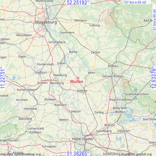
Wulfen GPS coordinates[2]
51° 49' 9.768" North, 11° 55' 50.268" East
| Map corner | latitude | longitude |
|---|---|---|
| Upper-left | 52.25192°, | 11.22751° |
| Center: | 51.81938°, | 11.93063° |
| Lower-right: | 51.38265°, | 12.63376° |
| Map W x H: | 96.7×96.7 km | = 60.1×60.1mi |
| max Lat: | 55.01917° ⇑29.9% North |
| Wulfen: | 51.81938° |
| min Lat: | ⇓70.1% South 47.40724° |
| min Long | Wulfen | max Long |
| 5.92978° | 11.93063° | 14.98853° |
| W 80.8%⇐ | ⇒19.2% E |
Elevation
Elevation of Wulfen is 69 m = 226 ft, and this is 180.1 m = 591 ft below average elevation for this country.
| Max E: |
1256 m = 4121 ft | 73.6% |
| Avg. | 249.1 m = 817 ft | |
| Wulfen | 69 m = 226 ft | |
Min E: |
-5 m = -16 ft | 26.4% |
See also: Germany elevation on elevation.city.
Geographical zone
Wulfen is located in North temperate zone (between Tropic of Cancer and the Arctic Circle). Distance of this North polar circle is 1639.4 km =1018.7 mi to North.| Distance of | km | miles | from Wulfen |
|---|---|---|---|
| North Pole | 4245.3 | 2637.9 | to North |
| Arctic Circle | 1639.4 | 1018.7 | to North |
| Tropic Cancer | 3155.9 | 1961 | to South |
| Equator | 5761.8 | 3580.2 | to South |


Nearby cities:
15 places around Wulfen: (largest is in red/bold)
• Aken
8.7 km =5.4 mi,  64°
64°
• Biendorf
9.5 km =5.9 mi,  216°
216°
• Drosa
1.7 km =1.1 mi,  257°
257°
• Elsnigk
9.2 km =5.7 mi,  109°
109°
• Gerbitz
7.6 km =4.7 mi,  289°
289°
• Großpaschleben
6.5 km =4 mi,  178°
178°
• Kleinpaschleben
5.1 km =3.2 mi, 218°
• Köthen
8 km =5 mi,  159°
159°
• Latdorf
9.1 km =5.7 mi, 262°
• Micheln
3 km =1.9 mi, 112°
• Osternienburg
7.2 km =4.5 mi, 113°
• Osternienburger Land
6.3 km =3.9 mi, 110°
• Poley
9 km =5.6 mi,  237°
237°
• Wohlsdorf
7.6 km =4.7 mi, 216°
• Zabitz
3.8 km =2.4 mi,  186°
186°
Sources, notices
• [Note1] Compared only with cities in Germany existing in our database
• [Src1] Map data: © OpenStreetMap contributors (CC-BY-SA)
• [Src2] Other city data from geonames.org with taken over terms of usage.
• [Src3] Geographical zone / Annual Mean Temperature by Robert A. Rohde @ Wikipedia
