Meudt geodata
Meudt (Rheinland-Pfalz) is a seat of a fourth-order administrative division; located in Germany in Europe/Berlin (GMT+2) time zone. With population of 1,783 people, there are 5372 cities with bigger population in this country. Compared to other cities in Germany, 52.8% of cities are located further ↑North; 79.1% of cities are located further →East and 68.4% of cities have lower elevation than Meudt. Note1


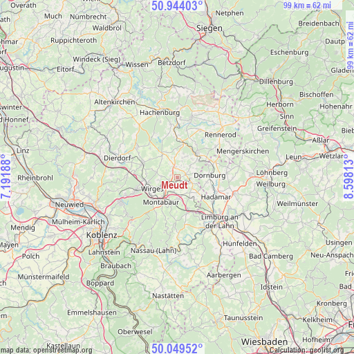
Meudt GPS coordinates[2]
50° 29' 56.004" North, 7° 53' 42" East
| Map corner | latitude | longitude |
|---|---|---|
| Upper-left | 50.94403°, | 7.19188° |
| Center: | 50.49889°, | 7.895° |
| Lower-right: | 50.04952°, | 8.59813° |
| Map W x H: | 99.5×99.5 km | = 61.8×61.8mi |
| max Lat: | 55.01917° ⇑52.8% North |
| Meudt: | 50.49889° |
| min Lat: | ⇓47.2% South 47.40724° |
| min Long | Meudt | max Long |
| 5.92978° | 7.895° | 14.98853° |
| W 20.9%⇐ | ⇒79.1% E |
Elevation
Elevation of Meudt is 346 m = 1135 ft, and this is 96.9 m = 318 ft above average elevation for this country.
| Max E: |
1256 m = 4121 ft | 31.6% |
| Meudt | 346 m 1135 ft | |
| Avg. | 249.1 m = 817 ft | |
Min E: |
-5 m = -16 ft | 68.4% |
See also: Germany elevation on elevation.city.
Geographical zone
Meudt is located in North temperate zone (between Tropic of Cancer and the Arctic Circle). Distance of this North polar circle is 1786.2 km =1109.9 mi to North.| Distance of | km | miles | from Meudt |
|---|---|---|---|
| North Pole | 4392.1 | 2729.1 | to North |
| Arctic Circle | 1786.2 | 1109.9 | to North |
| Tropic Cancer | 3009 | 1869.7 | to South |
| Equator | 5615 | 3489 | to South |


Nearby cities:
15 places around Meudt: (largest is in red/bold)
• Arnshöfen
5 km =3.1 mi,  339°
339°
• Berod bei Wallmerod
3.2 km =2 mi,  122°
122°
• Bilkheim
3.8 km =2.4 mi,  91°
91°
• Boden
3.9 km =2.4 mi,  224°
224°
• Ettinghausen
2.4 km =1.5 mi,  319°
319°
• Härtlingen
3.2 km =2 mi,  28°
28°
• Kuhnhöfen
4.4 km =2.7 mi,  329°
329°
• Moschheim
4.2 km =2.6 mi,  244°
244°
• Niederahr
2.5 km =1.6 mi,  252°
252°
• Oberahr
2 km =1.2 mi,  273°
273°
• Ruppach-Goldhausen
3.7 km =2.3 mi,  192°
192°
• Salz
5 km =3.1 mi,  75°
75°
• Wallmerod
4.3 km =2.7 mi,  113°
113°
• Zehnhausen bei Wallmerod
3.2 km =2 mi,  141°
141°
• Ötzingen
4.4 km =2.7 mi, 271°
Sources, notices
• [Note1] Compared only with cities in Germany existing in our database
• [Src1] Map data: © OpenStreetMap contributors (CC-BY-SA)
• [Src2] Other city data from geonames.org with taken over terms of usage.
• [Src3] Geographical zone / Annual Mean Temperature by Robert A. Rohde @ Wikipedia
