Kuhnhöfen geodata
Kuhnhöfen (Rheinland-Pfalz) is a seat of a fourth-order administrative division; located in Germany in Europe/Berlin (GMT+2) time zone. With population of 156 people, there are 10659 cities with bigger population in this country. Compared to other cities in Germany, 52.1% of cities are located further ↑North; 79.8% of cities are located further →East and 75.9% of cities have lower elevation than Kuhnhöfen. Note1


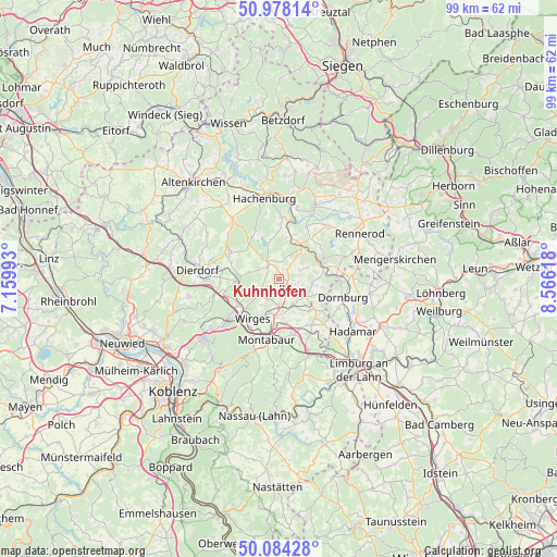
Kuhnhöfen GPS coordinates[2]
50° 31' 59.988" North, 7° 51' 47.016" East
| Map corner | latitude | longitude |
|---|---|---|
| Upper-left | 50.97814°, | 7.15993° |
| Center: | 50.53333°, | 7.86306° |
| Lower-right: | 50.08428°, | 8.56618° |
| Map W x H: | 99.4×99.4 km | = 61.8×61.8mi |
| max Lat: | 55.01917° ⇑52.1% North |
| Kuhnhöfen: | 50.53333° |
| min Lat: | ⇓47.9% South 47.40724° |
| min Long | Kuhnhöfen | max Long |
| 5.92978° | 7.86306° | 14.98853° |
| W 20.2%⇐ | ⇒79.8% E |
Elevation
Elevation of Kuhnhöfen is 405 m = 1329 ft, and this is 155.9 m = 511 ft above average elevation for this country.
| Max E: |
1256 m = 4121 ft | 24.1% |
| Kuhnhöfen | 405 m 1329 ft | |
| Avg. | 249.1 m = 817 ft | |
Min E: |
-5 m = -16 ft | 75.9% |
See also: Germany elevation on elevation.city.
Geographical zone
Kuhnhöfen is located in North temperate zone (between Tropic of Cancer and the Arctic Circle). Distance of this North polar circle is 1782.4 km =1107.5 mi to North.| Distance of | km | miles | from Kuhnhöfen |
|---|---|---|---|
| North Pole | 4388.3 | 2726.8 | to North |
| Arctic Circle | 1782.4 | 1107.5 | to North |
| Tropic Cancer | 3012.9 | 1872.1 | to South |
| Equator | 5618.8 | 3491.4 | to South |


Nearby cities:
15 places around Kuhnhöfen: (largest is in red/bold)
• Arnshöfen
0.9 km =0.6 mi,  31°
31°
• Ettinghausen
2.1 km =1.3 mi,  161°
161°
• Ewighausen
2.5 km =1.6 mi,  274°
274°
• Freilingen
3.5 km =2.2 mi,  325°
325°
• Helferskirchen
4.4 km =2.7 mi,  234°
234°
• Härtlingen
3.9 km =2.4 mi,  105°
105°
• Kaden
4 km =2.5 mi,  65°
65°
• Meudt
4.4 km =2.7 mi,  149°
149°
• Niederahr
4.6 km =2.9 mi,  181°
181°
• Niedersayn
2.3 km =1.4 mi,  256°
256°
• Oberahr
3.7 km =2.3 mi, 176°
• Rothenbach
4.5 km =2.8 mi,  39°
39°
• Weidenhahn
2.6 km =1.6 mi,  306°
306°
• Wölferlingen
3.6 km =2.2 mi,  346°
346°
• Ötzingen
4.3 km =2.7 mi,  209°
209°
Sources, notices
• [Note1] Compared only with cities in Germany existing in our database
• [Src1] Map data: © OpenStreetMap contributors (CC-BY-SA)
• [Src2] Other city data from geonames.org with taken over terms of usage.
• [Src3] Geographical zone / Annual Mean Temperature by Robert A. Rohde @ Wikipedia
