Härtlingen geodata
Härtlingen (Rheinland-Pfalz) is a seat of a fourth-order administrative division; located in Germany in Europe/Berlin (GMT+2) time zone. With population of 464 people, there are 9494 cities with bigger population in this country. Compared to other cities in Germany, 52.3% of cities are located further ↑North; 78.7% of cities are located further →East and 71.5% of cities have lower elevation than Härtlingen. Note1


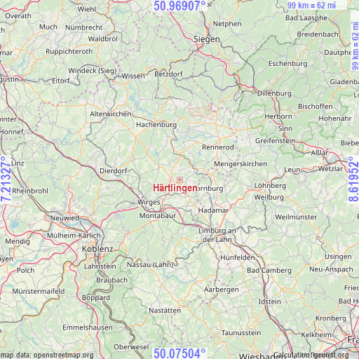
Härtlingen GPS coordinates[2]
50° 31' 27.012" North, 7° 54' 59.004" East
| Map corner | latitude | longitude |
|---|---|---|
| Upper-left | 50.96907°, | 7.21327° |
| Center: | 50.52417°, | 7.91639° |
| Lower-right: | 50.07504°, | 8.61952° |
| Map W x H: | 99.4×99.4 km | = 61.8×61.8mi |
| max Lat: | 55.01917° ⇑52.3% North |
| Härtlingen: | 50.52417° |
| min Lat: | ⇓47.7% South 47.40724° |
| min Long | Härtlingen | max Long |
| 5.92978° | 7.91639° | 14.98853° |
| W 21.3%⇐ | ⇒78.7% E |
Elevation
Elevation of Härtlingen is 370 m = 1214 ft, and this is 120.9 m = 397 ft above average elevation for this country.
| Max E: |
1256 m = 4121 ft | 28.5% |
| Härtlingen | 370 m 1214 ft | |
| Avg. | 249.1 m = 817 ft | |
Min E: |
-5 m = -16 ft | 71.5% |
See also: Germany elevation on elevation.city.
Geographical zone
Härtlingen is located in North temperate zone (between Tropic of Cancer and the Arctic Circle). Distance of this North polar circle is 1783.4 km =1108.2 mi to North.| Distance of | km | miles | from Härtlingen |
|---|---|---|---|
| North Pole | 4389.3 | 2727.4 | to North |
| Arctic Circle | 1783.4 | 1108.2 | to North |
| Tropic Cancer | 3011.8 | 1871.4 | to South |
| Equator | 5617.8 | 3490.7 | to South |


Nearby cities:
15 places around Härtlingen: (largest is in red/bold)
• Arnshöfen
3.8 km =2.4 mi,  299°
299°
• Berod bei Wallmerod
4.7 km =2.9 mi,  165°
165°
• Bilkheim
3.7 km =2.3 mi,  142°
142°
• Brandscheid
4.1 km =2.5 mi,  3°
3°
• Ettinghausen
3.2 km =2 mi,  252°
252°
• Girkenroth
3.9 km =2.4 mi,  95°
95°
• Guckheim
2.6 km =1.6 mi,  66°
66°
• Kaden
2.7 km =1.7 mi,  357°
357°
• Kuhnhöfen
3.9 km =2.4 mi,  285°
285°
• Kölbingen
3.1 km =1.9 mi,  22°
22°
• Meudt
3.2 km =2 mi,  208°
208°
• Oberahr
4.4 km =2.7 mi,  232°
232°
• Rothenbach
4.5 km =2.8 mi,  348°
348°
• Salz
3.7 km =2.3 mi,  115°
115°
• Weltersburg
3.3 km =2.1 mi, 73°
Sources, notices
• [Note1] Compared only with cities in Germany existing in our database
• [Src1] Map data: © OpenStreetMap contributors (CC-BY-SA)
• [Src2] Other city data from geonames.org with taken over terms of usage.
• [Src3] Geographical zone / Annual Mean Temperature by Robert A. Rohde @ Wikipedia
