Ettinghausen geodata
Ettinghausen (Rheinland-Pfalz) is a seat of a fourth-order administrative division; located in Germany in Europe/Berlin (GMT+2) time zone. With population of 329 people, there are 9951 cities with bigger population in this country. Compared to other cities in Germany, 52.5% of cities are located further ↑North; 79.5% of cities are located further →East and 75.9% of cities have lower elevation than Ettinghausen. Note1


Ettinghausen GPS coordinates[2]
50° 30' 56.304" North, 7° 52' 21.072" East
| Map corner | latitude | longitude |
|---|---|---|
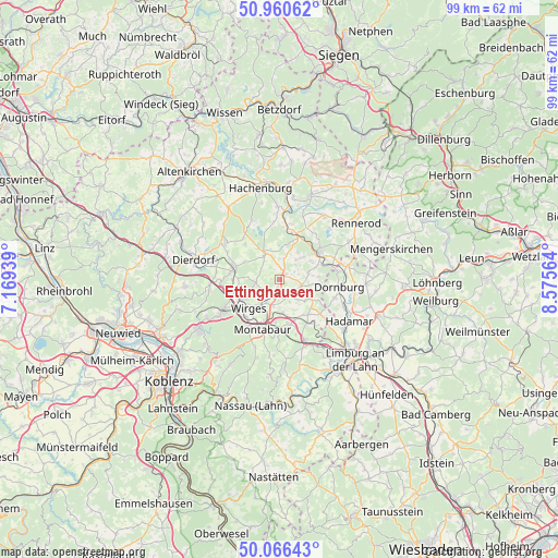
| Upper-left | 50.96062°, | 7.16939° |
| Center: | 50.51564°, | 7.87252° |
| Lower-right: | 50.06643°, | 8.57564° |
| Map W x H: | 99.4×99.4 km | = 61.8×61.8mi |
| max Lat: | 55.01917° ⇑52.5% North |
| Ettinghausen: | 50.51564° |
| min Lat: | ⇓47.5% South 47.40724° |
| min Long | Ettinghausen | max Long |
| 5.92978° | 7.87252° | 14.98853° |
| W 20.5%⇐ | ⇒79.5% E |
Elevation
Elevation of Ettinghausen is 405 m = 1329 ft, and this is 155.9 m = 511 ft above average elevation for this country.
| Max E: |
1256 m = 4121 ft | 24.1% |
| Ettinghausen | 405 m 1329 ft | |
| Avg. | 249.1 m = 817 ft | |
Min E: |
-5 m = -16 ft | 75.9% |
See also: Germany elevation on elevation.city.
Geographical zone
Ettinghausen is located in North temperate zone (between Tropic of Cancer and the Arctic Circle). Distance of this North polar circle is 1784.4 km =1108.8 mi to North.| Distance of | km | miles | from Ettinghausen |
|---|---|---|---|
| North Pole | 4390.2 | 2727.9 | to North |
| Arctic Circle | 1784.4 | 1108.8 | to North |
| Tropic Cancer | 3010.9 | 1870.9 | to South |
| Equator | 5616.8 | 3490.1 | to South |


Nearby cities:
15 places around Ettinghausen: (largest is in red/bold)
• Arnshöfen
2.8 km =1.7 mi,  356°
356°
• Boden
4.8 km =3 mi,  193°
193°
• Ewighausen
3.8 km =2.4 mi,  304°
304°
• Helferskirchen
4.3 km =2.7 mi,  262°
262°
• Härtlingen
3.2 km =2 mi,  72°
72°
• Kaden
4.7 km =2.9 mi,  39°
39°
• Kuhnhöfen
2.1 km =1.3 mi,  341°
341°
• Leuterod
4.4 km =2.7 mi,  239°
239°
• Meudt
2.4 km =1.5 mi,  139°
139°
• Moschheim
4.3 km =2.7 mi,  210°
210°
• Niederahr
2.8 km =1.7 mi,  197°
197°
• Niedersayn
3.2 km =2 mi, 296°
• Oberahr
1.8 km =1.1 mi, 193°
• Weidenhahn
4.4 km =2.7 mi,  322°
322°
• Ötzingen
3.3 km =2.1 mi, 237°
Sources, notices
• [Note1] Compared only with cities in Germany existing in our database
• [Src1] Map data: © OpenStreetMap contributors (CC-BY-SA)
• [Src2] Other city data from geonames.org with taken over terms of usage.
• [Src3] Geographical zone / Annual Mean Temperature by Robert A. Rohde @ Wikipedia
