Meppen geodata
Meppen (Lower Saxony) is a seat of a third-order administrative division; located in Germany in Europe/Berlin (GMT+2) time zone. With population of 34,198 people, there are 393 cities with bigger population in this country. Compared to other cities in Germany, 79.6% of cities are located further ↓South; 90.1% of cities are located further →East and 92.3% of cities have higher elevation than Meppen. Note1


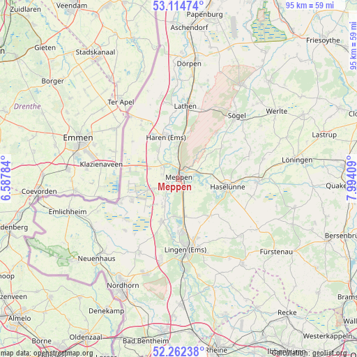
Meppen GPS coordinates[2]
52° 41' 26.304" North, 7° 17' 27.492" East
| Map corner | latitude | longitude |
|---|---|---|
| Upper-left | 53.11474°, | 6.58784° |
| Center: | 52.69064°, | 7.29097° |
| Lower-right: | 52.26238°, | 7.99409° |
| Map W x H: | 94.8×94.8 km | = 58.9×58.9mi |
| max Lat: | 55.01917° ⇑20.4% North |
| Meppen: | 52.69064° |
| min Lat: | ⇓79.6% South 47.40724° |
| min Long | Meppen | max Long |
| 5.92978° | 7.29097° | 14.98853° |
| W 9.9%⇐ | ⇒90.1% E |
Elevation
Elevation of Meppen is 15 m = 49 ft, and this is 234.1 m = 768 ft below average elevation for this country.
| Max E: |
1256 m = 4121 ft | 92.3% |
| Avg. | 249.1 m = 817 ft | |
| Meppen | 15 m = 49 ft | |
Min E: |
-5 m = -16 ft | 7.7% |
See also: Germany elevation on elevation.city.
Geographical zone
Meppen is located in North temperate zone (between Tropic of Cancer and the Arctic Circle). Distance of this North polar circle is 1542.5 km =958.5 mi to North.| Distance of | km | miles | from Meppen |
|---|---|---|---|
| North Pole | 4148.4 | 2577.7 | to North |
| Arctic Circle | 1542.5 | 958.5 | to North |
| Tropic Cancer | 3252.7 | 2021.1 | to South |
| Equator | 5858.6 | 3640.4 | to South |


Nearby cities:
15 places around Meppen: (largest is in red/bold)
• Bawinkel
12.5 km =7.8 mi,  143°
143°
• Geeste
10.2 km =6.3 mi,  189°
189°
• Georgsdorf
19.7 km =12.2 mi,  225°
225°
• Gersten
19.3 km =12 mi,  128°
128°
• Groß Berßen
16.4 km =10.2 mi,  56°
56°
• Haren
11.8 km =7.3 mi,  343°
343°
• Haselünne
13.2 km =8.2 mi,  98°
98°
• Hüven
18.4 km =11.4 mi, 55°
• Klein Berßen
14.4 km =8.9 mi,  53°
53°
• Lathen
19.6 km =12.2 mi,  5°
5°
• Lingen
18.9 km =11.7 mi,  174°
174°
• Lähden
19.8 km =12.3 mi,  72°
72°
• Niederlangen
18.5 km =11.5 mi,  358°
358°
• Oberlangen
17.8 km =11.1 mi,  354°
354°
• Twist
16.2 km =10.1 mi,  248°
248°
Sources, notices
• [Note1] Compared only with cities in Germany existing in our database
• [Src1] Map data: © OpenStreetMap contributors (CC-BY-SA)
• [Src2] Other city data from geonames.org with taken over terms of usage.
• [Src3] Geographical zone / Annual Mean Temperature by Robert A. Rohde @ Wikipedia
