Gersten geodata
Gersten (Lower Saxony) is a seat of a fourth-order administrative division; located in Germany in Europe/Berlin (GMT+2) time zone. With population of 1,212 people, there are 6533 cities with bigger population in this country. Compared to other cities in Germany, 78.5% of cities are located further ↓South; 86.8% of cities are located further →East and 89.7% of cities have higher elevation than Gersten. Note1


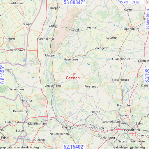
Gersten GPS coordinates[2]
52° 34' 59.988" North, 7° 31' 0.012" East
| Map corner | latitude | longitude |
|---|---|---|
| Upper-left | 53.00847°, | 6.81355° |
| Center: | 52.58333°, | 7.51667° |
| Lower-right: | 52.15402°, | 8.2198° |
| Map W x H: | 95×95 km | = 59×59mi |
| max Lat: | 55.01917° ⇑21.5% North |
| Gersten: | 52.58333° |
| min Lat: | ⇓78.5% South 47.40724° |
| min Long | Gersten | max Long |
| 5.92978° | 7.51667° | 14.98853° |
| W 13.2%⇐ | ⇒86.8% E |
Elevation
Elevation of Gersten is 22 m = 72 ft, and this is 227.1 m = 745 ft below average elevation for this country.
| Max E: |
1256 m = 4121 ft | 89.7% |
| Avg. | 249.1 m = 817 ft | |
| Gersten | 22 m = 72 ft | |
Min E: |
-5 m = -16 ft | 10.3% |
See also: Germany elevation on elevation.city.
Geographical zone
Gersten is located in North temperate zone (between Tropic of Cancer and the Arctic Circle). Distance of this North polar circle is 1554.5 km =965.9 mi to North.| Distance of | km | miles | from Gersten |
|---|---|---|---|
| North Pole | 4160.3 | 2585.1 | to North |
| Arctic Circle | 1554.5 | 965.9 | to North |
| Tropic Cancer | 3240.8 | 2013.7 | to South |
| Equator | 5846.7 | 3633 | to South |


Nearby cities:
15 places around Gersten: (largest is in red/bold)
• Andervenne Oberdorf
8.7 km =5.4 mi,  148°
148°
• Bawinkel
8.1 km =5 mi,  283°
283°
• Bippen
14.6 km =9.1 mi,  90°
90°
• Dohren
8.7 km =5.4 mi,  31°
31°
• Freren
10.9 km =6.8 mi,  170°
170°
• Fürstenau
13.1 km =8.1 mi,  124°
124°
• Handrup
4.6 km =2.9 mi, 117°
• Haselünne
10.3 km =6.4 mi,  347°
347°
• Herzlake
12.6 km =7.8 mi, 26°
• Langen
5.9 km =3.7 mi,  214°
214°
• Lengerich
3.4 km =2.1 mi,  162°
162°
• Lingen
15.1 km =9.4 mi,  242°
242°
• Messingen
13.4 km =8.3 mi,  194°
194°
• Thuine
9.5 km =5.9 mi, 193°
• Wettrup
5.6 km =3.5 mi,  83°
83°
Sources, notices
• [Note1] Compared only with cities in Germany existing in our database
• [Src1] Map data: © OpenStreetMap contributors (CC-BY-SA)
• [Src2] Other city data from geonames.org with taken over terms of usage.
• [Src3] Geographical zone / Annual Mean Temperature by Robert A. Rohde @ Wikipedia
