Menteroda geodata
Menteroda (Thuringia) is a seat of a fourth-order administrative division; located in Germany in Europe/Berlin (GMT+2) time zone. With population of 2,494 people, there are 4449 cities with bigger population in this country. Compared to other cities in Germany, 63.4% of cities are located further ↓South; 60% of cities are located further ←West and 78.5% of cities have lower elevation than Menteroda. Note1


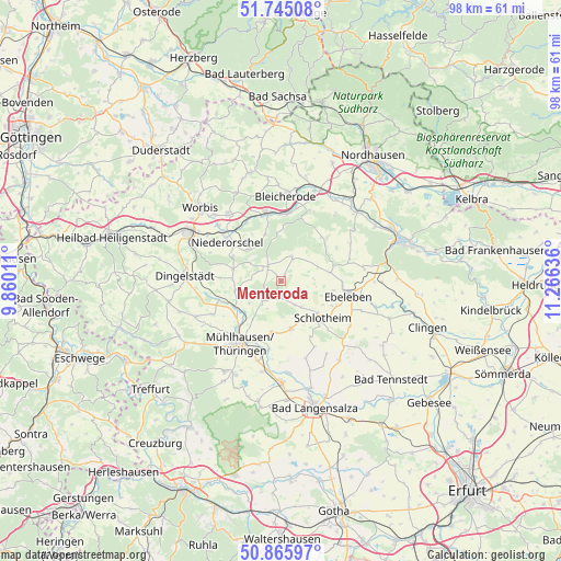
Menteroda GPS coordinates[2]
51° 18' 27.468" North, 10° 33' 47.628" East
| Map corner | latitude | longitude |
|---|---|---|
| Upper-left | 51.74508°, | 9.86011° |
| Center: | 51.30763°, | 10.56323° |
| Lower-right: | 50.86597°, | 11.26636° |
| Map W x H: | 97.7×97.7 km | = 60.7×60.7mi |
| max Lat: | 55.01917° ⇑36.6% North |
| Menteroda: | 51.30763° |
| min Lat: | ⇓63.4% South 47.40724° |
| min Long | Menteroda | max Long |
| 5.92978° | 10.56323° | 14.98853° |
| W 60%⇐ | ⇒40% E |
Elevation
Elevation of Menteroda is 423 m = 1388 ft, and this is 173.9 m = 571 ft above average elevation for this country.
| Max E: |
1256 m = 4121 ft | 21.5% |
| Menteroda | 423 m 1388 ft | |
| Avg. | 249.1 m = 817 ft | |
Min E: |
-5 m = -16 ft | 78.5% |
See also: Germany elevation on elevation.city.
Geographical zone
Menteroda is located in North temperate zone (between Tropic of Cancer and the Arctic Circle). Distance of this North polar circle is 1696.3 km =1054 mi to North.| Distance of | km | miles | from Menteroda |
|---|---|---|---|
| North Pole | 4302.2 | 2673.3 | to North |
| Arctic Circle | 1696.3 | 1054 | to North |
| Tropic Cancer | 3099 | 1925.6 | to South |
| Equator | 5704.9 | 3544.9 | to South |


Nearby cities:
15 places around Menteroda: (largest is in red/bold)
• Deuna
8.1 km =5 mi,  310°
310°
• Ebeleben
11.9 km =7.4 mi,  103°
103°
• Gerterode
10.1 km =6.3 mi,  326°
326°
• Holzsußra
8.8 km =5.5 mi,  107°
107°
• Körner
8.7 km =5.4 mi,  168°
168°
• Marolterode
11.7 km =7.3 mi,  134°
134°
• Niederorschel
12.1 km =7.5 mi, 306°
• Obergebra
11.8 km =7.3 mi,  5°
5°
• Obermehler
4.8 km =3 mi,  150°
150°
• Rehungen
8.8 km =5.5 mi,  341°
341°
• Schlotheim
9.5 km =5.9 mi,  135°
135°
• Sollstedt
5.2 km =3.2 mi,  272°
272°
• Sollstedt
12.3 km =7.6 mi,  350°
350°
• Urbach
3.3 km =2.1 mi,  116°
116°
• Vollenborn
6.4 km =4 mi,  317°
317°
Sources, notices
• [Note1] Compared only with cities in Germany existing in our database
• [Src1] Map data: © OpenStreetMap contributors (CC-BY-SA)
• [Src2] Other city data from geonames.org with taken over terms of usage.
• [Src3] Geographical zone / Annual Mean Temperature by Robert A. Rohde @ Wikipedia
