Allerbüttel geodata
Allerbüttel (Lower Saxony) is a populated place; located in Germany in Europe/Berlin (GMT+2) time zone. With population of 776 people, there are 7999 cities with bigger population in this country. Compared to other cities in Germany, 76.5% of cities are located further ↓South; 61.4% of cities are located further ←West and 76.1% of cities have higher elevation than Allerbüttel. Note1


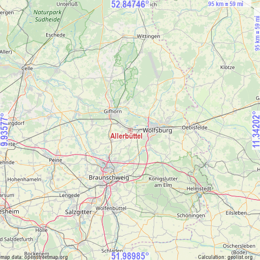
Allerbüttel GPS coordinates[2]
52° 25' 14.664" North, 10° 38' 20.004" East
| Map corner | latitude | longitude |
|---|---|---|
| Upper-left | 52.84746°, | 9.93577° |
| Center: | 52.42074°, | 10.63889° |
| Lower-right: | 51.98985°, | 11.34202° |
| Map W x H: | 95.4×95.4 km | = 59.3×59.3mi |
| max Lat: | 55.01917° ⇑23.5% North |
| Allerbüttel: | 52.42074° |
| min Lat: | ⇓76.5% South 47.40724° |
| min Long | Allerbüttel | max Long |
| 5.92978° | 10.63889° | 14.98853° |
| W 61.4%⇐ | ⇒38.6% E |
Elevation
Elevation of Allerbüttel is 59 m = 194 ft, and this is 190.1 m = 624 ft below average elevation for this country.
| Max E: |
1256 m = 4121 ft | 76.1% |
| Avg. | 249.1 m = 817 ft | |
| Allerbüttel | 59 m = 194 ft | |
Min E: |
-5 m = -16 ft | 23.9% |
See also: Germany elevation on elevation.city.
Geographical zone
Allerbüttel is located in North temperate zone (between Tropic of Cancer and the Arctic Circle). Distance of this North polar circle is 1572.5 km =977.1 mi to North.| Distance of | km | miles | from Allerbüttel |
|---|---|---|---|
| North Pole | 4178.4 | 2596.3 | to North |
| Arctic Circle | 1572.5 | 977.1 | to North |
| Tropic Cancer | 3222.7 | 2002.5 | to South |
| Equator | 5828.6 | 3621.7 | to South |


Nearby cities:
15 places around Allerbüttel: (largest is in red/bold)
• Abbesbüttel
9.4 km =5.8 mi,  216°
216°
• Calberlah
1.1 km =0.7 mi,  270°
270°
• Detmerode
7.9 km =4.9 mi,  115°
115°
• Gifhorn
8.7 km =5.4 mi,  316°
316°
• Isenbüttel
4 km =2.5 mi,  290°
290°
• Lehre
9.9 km =6.2 mi,  169°
169°
• Meine
7.8 km =4.8 mi,  239°
239°
• Osloß
6.1 km =3.8 mi,  27°
27°
• Ribbesbüttel
8.9 km =5.5 mi,  279°
279°
• Rötgesbüttel
7.2 km =4.5 mi, 266°
• Tappenbeck
8.8 km =5.5 mi,  51°
51°
• Wasbüttel
3.2 km =2 mi,  254°
254°
• Westhagen
7.1 km =4.4 mi,  105°
105°
• Weyhausen
7 km =4.3 mi, 49°
• Wolfsburg
9.7 km =6 mi,  87°
87°
Sources, notices
• [Note1] Compared only with cities in Germany existing in our database
• [Src1] Map data: © OpenStreetMap contributors (CC-BY-SA)
• [Src2] Other city data from geonames.org with taken over terms of usage.
• [Src3] Geographical zone / Annual Mean Temperature by Robert A. Rohde @ Wikipedia
