Isenbüttel geodata
Isenbüttel (Lower Saxony) is a seat of a fourth-order administrative division; located in Germany in Europe/Berlin (GMT+2) time zone. With population of 6,277 people, there are 2374 cities with bigger population in this country. Compared to other cities in Germany, 76.6% of cities are located further ↓South; 60.4% of cities are located further ←West and 75.8% of cities have higher elevation than Isenbüttel. Note1


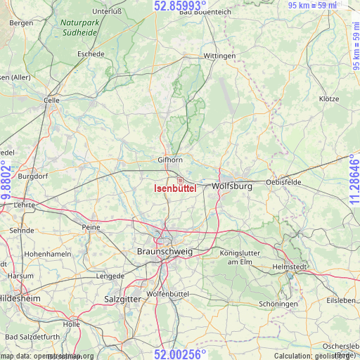
Isenbüttel GPS coordinates[2]
52° 25' 59.988" North, 10° 34' 59.988" East
| Map corner | latitude | longitude |
|---|---|---|
| Upper-left | 52.85993°, | 9.8802° |
| Center: | 52.43333°, | 10.58333° |
| Lower-right: | 52.00256°, | 11.28646° |
| Map W x H: | 95.3×95.3 km | = 59.2×59.2mi |
| max Lat: | 55.01917° ⇑23.4% North |
| Isenbüttel: | 52.43333° |
| min Lat: | ⇓76.6% South 47.40724° |
| min Long | Isenbüttel | max Long |
| 5.92978° | 10.58333° | 14.98853° |
| W 60.4%⇐ | ⇒39.6% E |
Elevation
Elevation of Isenbüttel is 60 m = 197 ft, and this is 189.1 m = 620 ft below average elevation for this country.
| Max E: |
1256 m = 4121 ft | 75.8% |
| Avg. | 249.1 m = 817 ft | |
| Isenbüttel | 60 m = 197 ft | |
Min E: |
-5 m = -16 ft | 24.2% |
See also: Germany elevation on elevation.city.
Geographical zone
Isenbüttel is located in North temperate zone (between Tropic of Cancer and the Arctic Circle). Distance of this North polar circle is 1571.1 km =976.2 mi to North.| Distance of | km | miles | from Isenbüttel |
|---|---|---|---|
| North Pole | 4177 | 2595.5 | to North |
| Arctic Circle | 1571.1 | 976.2 | to North |
| Tropic Cancer | 3224.1 | 2003.4 | to South |
| Equator | 5830 | 3622.6 | to South |


Nearby cities:
15 places around Isenbüttel: (largest is in red/bold)
• Abbesbüttel
9.2 km =5.7 mi,  191°
191°
• Allerbüttel
4 km =2.5 mi,  110°
110°
• Bevenrode
10.4 km =6.5 mi,  182°
182°
• Calberlah
3 km =1.9 mi,  117°
117°
• Gifhorn
5.4 km =3.4 mi,  336°
336°
• Leiferde
10.1 km =6.3 mi,  273°
273°
• Meine
6.2 km =3.9 mi,  209°
209°
• Osloß
7.7 km =4.8 mi,  58°
58°
• Rethen
9.5 km =5.9 mi,  228°
228°
• Ribbesbüttel
5 km =3.1 mi, 271°
• Rötgesbüttel
3.9 km =2.4 mi,  241°
241°
• Sassenburg
9.9 km =6.2 mi,  20°
20°
• Vordorf
8.7 km =5.4 mi, 209°
• Wasbüttel
2.3 km =1.4 mi,  162°
162°
• Weyhausen
9.6 km =6 mi,  70°
70°
Sources, notices
• [Note1] Compared only with cities in Germany existing in our database
• [Src1] Map data: © OpenStreetMap contributors (CC-BY-SA)
• [Src2] Other city data from geonames.org with taken over terms of usage.
• [Src3] Geographical zone / Annual Mean Temperature by Robert A. Rohde @ Wikipedia
