Höheinöd geodata
Höheinöd (Rheinland-Pfalz) is a seat of a fourth-order administrative division; located in Germany in Europe/Berlin (GMT+2) time zone. With population of 1,253 people, there are 6430 cities with bigger population in this country. Compared to other cities in Germany, 78.9% of cities are located further ↑North; 84.9% of cities are located further →East and 76.1% of cities have lower elevation than Höheinöd. Note1


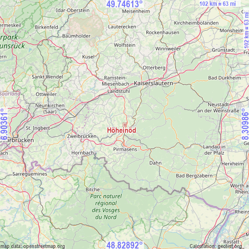
Höheinöd GPS coordinates[2]
49° 17' 22.776" North, 7° 36' 24.228" East
| Map corner | latitude | longitude |
|---|---|---|
| Upper-left | 49.74613°, | 6.90361° |
| Center: | 49.28966°, | 7.60673° |
| Lower-right: | 48.82892°, | 8.30986° |
| Map W x H: | 102×102 km | = 63.4×63.4mi |
| max Lat: | 55.01917° ⇑78.9% North |
| Höheinöd: | 49.28966° |
| min Lat: | ⇓21.1% South 47.40724° |
| min Long | Höheinöd | max Long |
| 5.92978° | 7.60673° | 14.98853° |
| W 15.1%⇐ | ⇒84.9% E |
Elevation
Elevation of Höheinöd is 406 m = 1332 ft, and this is 156.9 m = 515 ft above average elevation for this country.
| Max E: |
1256 m = 4121 ft | 23.9% |
| Höheinöd | 406 m 1332 ft | |
| Avg. | 249.1 m = 817 ft | |
Min E: |
-5 m = -16 ft | 76.1% |
See also: Germany elevation on elevation.city.
Geographical zone
Höheinöd is located in North temperate zone (between Tropic of Cancer and the Arctic Circle). Distance of this North polar circle is 1920.7 km =1193.5 mi to North.| Distance of | km | miles | from Höheinöd |
|---|---|---|---|
| North Pole | 4526.6 | 2812.7 | to North |
| Arctic Circle | 1920.7 | 1193.5 | to North |
| Tropic Cancer | 2874.6 | 1786.2 | to South |
| Equator | 5480.5 | 3405.4 | to South |


Nearby cities:
15 places around Höheinöd: (largest is in red/bold)
• Clausen
6 km =3.7 mi,  122°
122°
• Donsieders
3.7 km =2.3 mi,  136°
136°
• Hermersberg
3.6 km =2.2 mi,  32°
32°
• Herschberg
4.6 km =2.9 mi,  291°
291°
• Hettenhausen
6.4 km =4 mi,  319°
319°
• Horbach
5.8 km =3.6 mi, 32°
• Höhfröschen
5.3 km =3.3 mi,  213°
213°
• Maßweiler
5.9 km =3.7 mi,  244°
244°
• Rodalben
6.1 km =3.8 mi,  156°
156°
• Saalstadt
5.1 km =3.2 mi,  306°
306°
• Schauerberg
3.4 km =2.1 mi,  330°
330°
• Steinalben
4.3 km =2.7 mi,  46°
46°
• Thaleischweiler-Fröschen
3.1 km =1.9 mi, 213°
• Waldfischbach-Burgalben
4.4 km =2.7 mi,  99°
99°
• Weselberg
5.2 km =3.2 mi,  0°
0°
Sources, notices
• [Note1] Compared only with cities in Germany existing in our database
• [Src1] Map data: © OpenStreetMap contributors (CC-BY-SA)
• [Src2] Other city data from geonames.org with taken over terms of usage.
• [Src3] Geographical zone / Annual Mean Temperature by Robert A. Rohde @ Wikipedia
