Maßbach geodata
Maßbach (Bavaria) is a populated place; located in Germany in Europe/Berlin (GMT+2) time zone. With population of 4,819 people, there are 2893 cities with bigger population in this country. Compared to other cities in Germany, 59.4% of cities are located further ↑North; 54.8% of cities are located further ←West and 59.1% of cities have lower elevation than Maßbach. Note1
Administrative division(s):
- Level 1: Bavaria
- Level 2: Regierungsbezirk Unterfranken
- Level 3: Landkreis Bad Kissingen
- Level 4: Maßbach, Markt


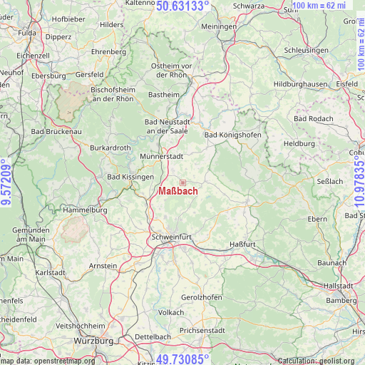
Maßbach GPS coordinates[2]
50° 10' 59.556" North, 10° 16' 30.792" East
| Map corner | latitude | longitude |
|---|---|---|
| Upper-left | 50.63133°, | 9.57209° |
| Center: | 50.18321°, | 10.27522° |
| Lower-right: | 49.73085°, | 10.97835° |
| Map W x H: | 100.1×100.1 km | = 62.2×62.2mi |
| max Lat: | 55.01917° ⇑59.4% North |
| Maßbach: | 50.18321° |
| min Lat: | ⇓40.6% South 47.40724° |
| min Long | Maßbach | max Long |
| 5.92978° | 10.27522° | 14.98853° |
| W 54.8%⇐ | ⇒45.2% E |
Elevation
Elevation of Maßbach is 284 m = 932 ft, and this is 34.9 m = 115 ft above average elevation for this country.
| Max E: |
1256 m = 4121 ft | 40.9% |
| Maßbach | 284 m 932 ft | |
| Avg. | 249.1 m = 817 ft | |
Min E: |
-5 m = -16 ft | 59.1% |
See also: Germany elevation on elevation.city.
Geographical zone
Maßbach is located in North temperate zone (between Tropic of Cancer and the Arctic Circle). Distance of this North polar circle is 1821.3 km =1131.7 mi to North.| Distance of | km | miles | from Maßbach |
|---|---|---|---|
| North Pole | 4427.2 | 2750.9 | to North |
| Arctic Circle | 1821.3 | 1131.7 | to North |
| Tropic Cancer | 2973.9 | 1847.9 | to South |
| Equator | 5579.8 | 3467.1 | to South |


Nearby cities:
15 places around Maßbach: (largest is in red/bold)
• Aidhausen
11.9 km =7.4 mi,  108°
108°
• Burglauer
12.4 km =7.7 mi,  326°
326°
• Dittelbrunn
13 km =8.1 mi,  197°
197°
• Großbardorf
11.3 km =7 mi,  35°
35°
• Hausen
12.7 km =7.9 mi,  168°
168°
• Münnerstadt
8.7 km =5.4 mi,  323°
323°
• Nüdlingen
11.6 km =7.2 mi,  291°
291°
• Oerlenbach
10.8 km =6.7 mi,  249°
249°
• Poppenhausen
13.2 km =8.2 mi,  225°
225°
• Rannungen
5.4 km =3.4 mi, 248°
• Stadtlauringen
6.2 km =3.9 mi,  85°
85°
• Strahlungen
11.5 km =7.1 mi,  345°
345°
• Sulzfeld
12.6 km =7.8 mi,  47°
47°
• Thundorf in Unterfranken
3.7 km =2.3 mi,  57°
57°
• Üchtelhausen
10.2 km =6.3 mi,  182°
182°
Sources, notices
• [Note1] Compared only with cities in Germany existing in our database
• [Src1] Map data: © OpenStreetMap contributors (CC-BY-SA)
• [Src2] Other city data from geonames.org with taken over terms of usage.
• [Src3] Geographical zone / Annual Mean Temperature by Robert A. Rohde @ Wikipedia
