Rannungen geodata
Rannungen (Bavaria) is a seat of a fourth-order administrative division; located in Germany in Europe/Berlin (GMT+2) time zone. With population of 1,209 people, there are 6538 cities with bigger population in this country. Compared to other cities in Germany, 59.7% of cities are located further ↑North; 53.4% of cities are located further ←West and 68% of cities have lower elevation than Rannungen. Note1
Administrative division(s):
- Level 1: Bavaria
- Level 2: Regierungsbezirk Unterfranken
- Level 3: Landkreis Bad Kissingen
- Level 4: Rannungen


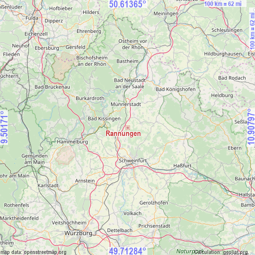
Rannungen GPS coordinates[2]
50° 9' 55.332" North, 10° 12' 17.424" East
| Map corner | latitude | longitude |
|---|---|---|
| Upper-left | 50.61365°, | 9.50171° |
| Center: | 50.16537°, | 10.20484° |
| Lower-right: | 49.71284°, | 10.90797° |
| Map W x H: | 100.2×100.2 km | = 62.3×62.3mi |
| max Lat: | 55.01917° ⇑59.7% North |
| Rannungen: | 50.16537° |
| min Lat: | ⇓40.3% South 47.40724° |
| min Long | Rannungen | max Long |
| 5.92978° | 10.20484° | 14.98853° |
| W 53.4%⇐ | ⇒46.6% E |
Elevation
Elevation of Rannungen is 342 m = 1122 ft, and this is 92.9 m = 305 ft above average elevation for this country.
| Max E: |
1256 m = 4121 ft | 32% |
| Rannungen | 342 m 1122 ft | |
| Avg. | 249.1 m = 817 ft | |
Min E: |
-5 m = -16 ft | 68% |
See also: Germany elevation on elevation.city.
Geographical zone
Rannungen is located in North temperate zone (between Tropic of Cancer and the Arctic Circle). Distance of this North polar circle is 1823.3 km =1132.9 mi to North.| Distance of | km | miles | from Rannungen |
|---|---|---|---|
| North Pole | 4429.2 | 2752.2 | to North |
| Arctic Circle | 1823.3 | 1132.9 | to North |
| Tropic Cancer | 2971.9 | 1846.7 | to South |
| Equator | 5577.9 | 3465.9 | to South |


Nearby cities:
15 places around Rannungen: (largest is in red/bold)
• Bad Kissingen
9.9 km =6.2 mi,  294°
294°
• Burglauer
12.5 km =7.8 mi,  351°
351°
• Dittelbrunn
10.4 km =6.5 mi,  174°
174°
• Euerbach
12.5 km =7.8 mi,  202°
202°
• Maßbach
5.4 km =3.4 mi,  68°
68°
• Münnerstadt
9 km =5.6 mi,  358°
358°
• Niederwerrn
11.7 km =7.3 mi,  187°
187°
• Nüdlingen
8.5 km =5.3 mi,  316°
316°
• Oerlenbach
5.4 km =3.4 mi,  251°
251°
• Poppenhausen
8.5 km =5.3 mi,  211°
211°
• Ramsthal
10.2 km =6.3 mi, 254°
• Stadtlauringen
11.4 km =7.1 mi,  77°
77°
• Sulzthal
12.7 km =7.9 mi, 253°
• Thundorf in Unterfranken
9 km =5.6 mi,  64°
64°
• Üchtelhausen
9.4 km =5.8 mi,  150°
150°
Sources, notices
• [Note1] Compared only with cities in Germany existing in our database
• [Src1] Map data: © OpenStreetMap contributors (CC-BY-SA)
• [Src2] Other city data from geonames.org with taken over terms of usage.
• [Src3] Geographical zone / Annual Mean Temperature by Robert A. Rohde @ Wikipedia
