Thundorf in Unterfranken geodata
Thundorf in Unterfranken (Bavaria) is a populated place; located in Germany in Europe/Berlin (GMT+2) time zone. With population of 1,202 people, there are 6555 cities with bigger population in this country. Compared to other cities in Germany, 58.9% of cities are located further ↑North; 55.8% of cities are located further ←West and 63.4% of cities have lower elevation than Thundorf in Unterfranken. Note1
Administrative division(s):
- Level 1: Bavaria
- Level 2: Regierungsbezirk Unterfranken
- Level 3: Landkreis Bad Kissingen
- Level 4: Thundorf i.UFr.
Current local time in Thundorf in Unterfranken:
05:12 PM, TuesdayDifference from your time zone: hours


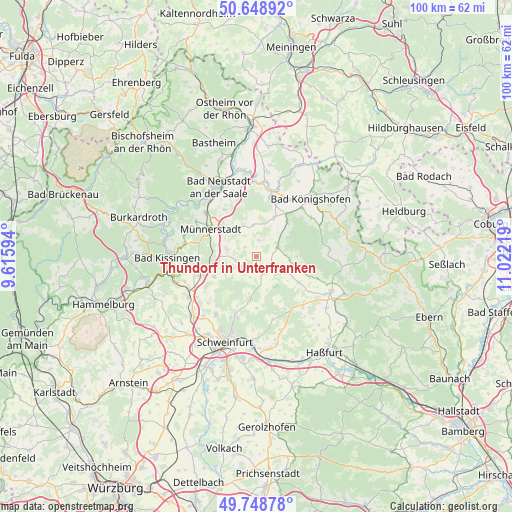
Thundorf in Unterfranken GPS coordinates[2]
50° 12' 3.492" North, 10° 19' 8.616" East
| Map corner | latitude | longitude |
|---|---|---|
| Upper-left | 50.64892°, | 9.61594° |
| Center: | 50.20097°, | 10.31906° |
| Lower-right: | 49.74878°, | 11.02219° |
| Map W x H: | 100.1×100.1 km | = 62.2×62.2mi |
| max Lat: | 55.01917° ⇑58.9% North |
| Thundorf in Unterfranken: | 50.20097° |
| min Lat: | ⇓41.1% South 47.40724° |
| min Long | Thundorf in Unt | max Long |
| 5.92978° | 10.31906° | 14.98853° |
| W 55.8%⇐ | ⇒44.2% E |
Elevation
Elevation of Thundorf in Unterfranken is 311 m = 1020 ft, and this is 61.9 m = 203 ft above average elevation for this country.
| Max E: |
1256 m = 4121 ft | 36.6% |
| Thundorf in Unterfranken | 311 m 1020 ft | |
| Avg. | 249.1 m = 817 ft | |
Min E: |
-5 m = -16 ft | 63.4% |
See also: Germany elevation on elevation.city.
Geographical zone
Thundorf in Unterfranken is located in North temperate zone (between Tropic of Cancer and the Arctic Circle). Distance of this North polar circle is 1819.3 km =1130.5 mi to North.| Distance of | km | miles | from Thundorf in Unterfranken |
|---|---|---|---|
| North Pole | 4425.2 | 2749.7 | to North |
| Arctic Circle | 1819.3 | 1130.5 | to North |
| Tropic Cancer | 2975.9 | 1849.1 | to South |
| Equator | 5581.8 | 3468.4 | to South |


Nearby cities:
15 places around Thundorf in Unterfranken: (largest is in red/bold)
• Aidhausen
9.9 km =6.2 mi,  124°
124°
• Bundorf
14.2 km =8.8 mi,  82°
82°
• Burglauer
13 km =8.1 mi,  310°
310°
• Großbardorf
8.1 km =5 mi,  24°
24°
• Großeibstadt
12.9 km =8 mi,  30°
30°
• Maßbach
3.7 km =2.3 mi,  237°
237°
• Münnerstadt
9.7 km =6 mi,  301°
301°
• Nüdlingen
14.1 km =8.8 mi,  278°
278°
• Rannungen
9 km =5.6 mi, 244°
• Rödelmaier
13.5 km =8.4 mi,  347°
347°
• Saal an der Saale
13.2 km =8.2 mi,  12°
12°
• Stadtlauringen
3.4 km =2.1 mi, 117°
• Strahlungen
11 km =6.8 mi,  326°
326°
• Sulzfeld
9 km =5.6 mi,  43°
43°
• Üchtelhausen
12.7 km =7.9 mi,  196°
196°
Sources, notices
• [Note1] Compared only with cities in Germany existing in our database
• [Src1] Map data: © OpenStreetMap contributors (CC-BY-SA)
• [Src2] Other city data from geonames.org with taken over terms of usage.
• [Src3] Geographical zone / Annual Mean Temperature by Robert A. Rohde @ Wikipedia
