Arzberg geodata
Arzberg (Bavaria) is a populated place; located in Germany in Europe/Berlin (GMT+2) time zone. With population of 6,075 people, there are 2439 cities with bigger population in this country. Compared to other cities in Germany, 62.3% of cities are located further ↑North; 84.5% of cities are located further ←West and 85.1% of cities have lower elevation than Arzberg. Note1
Administrative division(s):
- Level 1: Bavaria
- Level 2: Upper Franconia
- Level 3: Landkreis Wunsiedel im Fichtelgebirge
- Level 4: Arzberg


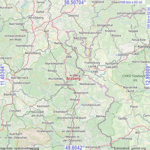
Arzberg GPS coordinates[2]
50° 3' 27.864" North, 12° 11' 12.336" East
| Map corner | latitude | longitude |
|---|---|---|
| Upper-left | 50.50704°, | 11.48364° |
| Center: | 50.05774°, | 12.18676° |
| Lower-right: | 49.6042°, | 12.88989° |
| Map W x H: | 100.4×100.4 km | = 62.4×62.4mi |
| max Lat: | 55.01917° ⇑62.3% North |
| Arzberg: | 50.05774° |
| min Lat: | ⇓37.7% South 47.40724° |
| min Long | Arzberg | max Long |
| 5.92978° | 12.18676° | 14.98853° |
| W 84.5%⇐ | ⇒15.5% E |
Elevation
Elevation of Arzberg is 470 m = 1542 ft, and this is 220.9 m = 725 ft above average elevation for this country.
| Max E: |
1256 m = 4121 ft | 14.9% |
| Arzberg | 470 m 1542 ft | |
| Avg. | 249.1 m = 817 ft | |
Min E: |
-5 m = -16 ft | 85.1% |
See also: Germany elevation on elevation.city.
Geographical zone
Arzberg is located in North temperate zone (between Tropic of Cancer and the Arctic Circle). Distance of this North polar circle is 1835.3 km =1140.4 mi to North.| Distance of | km | miles | from Arzberg |
|---|---|---|---|
| North Pole | 4441.2 | 2759.6 | to North |
| Arctic Circle | 1835.3 | 1140.4 | to North |
| Tropic Cancer | 2960 | 1839.3 | to South |
| Equator | 5565.9 | 3458.5 | to South |


Nearby cities:
15 places around Arzberg: (largest is in red/bold)
• Bad Alexandersbad
13 km =8.1 mi,  249°
249°
• Hohenberg an der Eger
4.8 km =3 mi,  29°
29°
• Höchstädt bei Thiersheim
8.6 km =5.3 mi,  304°
304°
• Leonberg
14.2 km =8.8 mi,  150°
150°
• Marktredwitz
9.3 km =5.8 mi,  230°
230°
• Mitterteich
12.5 km =7.8 mi,  161°
161°
• Pechbrunn
10.2 km =6.3 mi,  188°
188°
• Röslau
14.8 km =9.2 mi,  281°
281°
• Schirnding
4 km =2.5 mi,  47°
47°
• Selb
13.2 km =8.2 mi,  342°
342°
• Thiersheim
4.8 km =3 mi, 295°
• Thierstein
8.1 km =5 mi,  311°
311°
• Waldershof
12.3 km =7.6 mi, 226°
• Waldsassen
10.5 km =6.5 mi,  126°
126°
• Wunsiedel
13.3 km =8.3 mi,  261°
261°
Sources, notices
• [Note1] Compared only with cities in Germany existing in our database
• [Src1] Map data: © OpenStreetMap contributors (CC-BY-SA)
• [Src2] Other city data from geonames.org with taken over terms of usage.
• [Src3] Geographical zone / Annual Mean Temperature by Robert A. Rohde @ Wikipedia
