Mahlwinkel geodata
Mahlwinkel (Saxony-Anhalt) is a populated place; located in Germany in Europe/Berlin (GMT+2) time zone. With population of 616 people, there are 8739 cities with bigger population in this country. Compared to other cities in Germany, 76.1% of cities are located further ↓South; 78.6% of cities are located further ←West and 83.2% of cities have higher elevation than Mahlwinkel. Note1


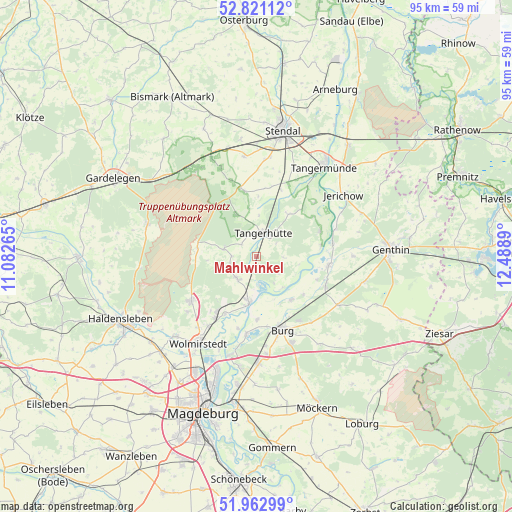
Mahlwinkel GPS coordinates[2]
52° 23' 38.904" North, 11° 47' 8.772" East
| Map corner | latitude | longitude |
|---|---|---|
| Upper-left | 52.82112°, | 11.08265° |
| Center: | 52.39414°, | 11.78577° |
| Lower-right: | 51.96299°, | 12.4889° |
| Map W x H: | 95.4×95.4 km | = 59.3×59.3mi |
| max Lat: | 55.01917° ⇑23.9% North |
| Mahlwinkel: | 52.39414° |
| min Lat: | ⇓76.1% South 47.40724° |
| min Long | Mahlwinkel | max Long |
| 5.92978° | 11.78577° | 14.98853° |
| W 78.6%⇐ | ⇒21.4% E |
Elevation
Elevation of Mahlwinkel is 39 m = 128 ft, and this is 210.1 m = 689 ft below average elevation for this country.
| Max E: |
1256 m = 4121 ft | 83.2% |
| Avg. | 249.1 m = 817 ft | |
| Mahlwinkel | 39 m = 128 ft | |
Min E: |
-5 m = -16 ft | 16.8% |
See also: Germany elevation on elevation.city.
Geographical zone
Mahlwinkel is located in North temperate zone (between Tropic of Cancer and the Arctic Circle). Distance of this North polar circle is 1575.5 km =979 mi to North.| Distance of | km | miles | from Mahlwinkel |
|---|---|---|---|
| North Pole | 4181.4 | 2598.2 | to North |
| Arctic Circle | 1575.5 | 979 | to North |
| Tropic Cancer | 3219.8 | 2000.7 | to South |
| Equator | 5825.7 | 3619.9 | to South |


Nearby cities:
15 places around Mahlwinkel: (largest is in red/bold)
• Angern
6.1 km =3.8 mi,  215°
215°
• Bittkau
12.2 km =7.6 mi,  79°
79°
• Burg bei Magdeburg
14.4 km =8.9 mi,  160°
160°
• Burgstall
6.3 km =3.9 mi,  284°
284°
• Colbitz
15 km =9.3 mi,  235°
235°
• Dolle
11 km =6.8 mi, 278°
• Farsleben
15.8 km =9.8 mi,  214°
214°
• Ferchland
15.4 km =9.6 mi,  70°
70°
• Grieben
12.8 km =8 mi, 68°
• Loitsche
12.1 km =7.5 mi, 208°
• Lüderitz
13.1 km =8.1 mi,  347°
347°
• Reesen
16 km =9.9 mi,  139°
139°
• Rogätz
8.7 km =5.4 mi,  188°
188°
• Tangerhütte
4.8 km =3 mi,  17°
17°
• Zielitz
13.8 km =8.6 mi, 212°
Sources, notices
• [Note1] Compared only with cities in Germany existing in our database
• [Src1] Map data: © OpenStreetMap contributors (CC-BY-SA)
• [Src2] Other city data from geonames.org with taken over terms of usage.
• [Src3] Geographical zone / Annual Mean Temperature by Robert A. Rohde @ Wikipedia
