Ferchland geodata
Ferchland (Saxony-Anhalt) is a populated place; located in Germany in Europe/Berlin (GMT+2) time zone. With population of 600 people, there are 8822 cities with bigger population in this country. Compared to other cities in Germany, 76.8% of cities are located further ↓South; 81.8% of cities are located further ←West and 84.5% of cities have higher elevation than Ferchland. Note1


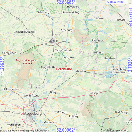
Ferchland GPS coordinates[2]
52° 26' 25.152" North, 11° 59' 58.092" East
| Map corner | latitude | longitude |
|---|---|---|
| Upper-left | 52.86685°, | 11.29635° |
| Center: | 52.44032°, | 11.99947° |
| Lower-right: | 52.00962°, | 12.7026° |
| Map W x H: | 95.3×95.3 km | = 59.2×59.2mi |
| max Lat: | 55.01917° ⇑23.2% North |
| Ferchland: | 52.44032° |
| min Lat: | ⇓76.8% South 47.40724° |
| min Long | Ferchland | max Long |
| 5.92978° | 11.99947° | 14.98853° |
| W 81.8%⇐ | ⇒18.2% E |
Elevation
Elevation of Ferchland is 36 m = 118 ft, and this is 213.1 m = 699 ft below average elevation for this country.
| Max E: |
1256 m = 4121 ft | 84.5% |
| Avg. | 249.1 m = 817 ft | |
| Ferchland | 36 m = 118 ft | |
Min E: |
-5 m = -16 ft | 15.5% |
See also: Germany elevation on elevation.city.
Geographical zone
Ferchland is located in North temperate zone (between Tropic of Cancer and the Arctic Circle). Distance of this North polar circle is 1570.4 km =975.8 mi to North.| Distance of | km | miles | from Ferchland |
|---|---|---|---|
| North Pole | 4176.2 | 2595 | to North |
| Arctic Circle | 1570.4 | 975.8 | to North |
| Tropic Cancer | 3224.9 | 2003.9 | to South |
| Equator | 5830.8 | 3623.1 | to South |


Nearby cities:
15 places around Ferchland: (largest is in red/bold)
• Bittkau
3.9 km =2.4 mi,  219°
219°
• Brettin
12.5 km =7.8 mi,  97°
97°
• Fischbeck
11.1 km =6.9 mi,  6°
6°
• Genthin
11.5 km =7.1 mi,  109°
109°
• Grieben
2.6 km =1.6 mi,  262°
262°
• Heeren
13.7 km =8.5 mi,  326°
326°
• Jerichow
6.9 km =4.3 mi, 13°
• Mahlwinkel
15.4 km =9.6 mi,  250°
250°
• Mützel
13.7 km =8.5 mi,  119°
119°
• Redekin
6 km =3.7 mi,  59°
59°
• Roßdorf
14.2 km =8.8 mi, 96°
• Schönhausen
15.8 km =9.8 mi, 9°
• Tangerhütte
13 km =8.1 mi,  267°
267°
• Tangermünde
11.7 km =7.3 mi,  352°
352°
• Wust
14.6 km =9.1 mi,  32°
32°
Sources, notices
• [Note1] Compared only with cities in Germany existing in our database
• [Src1] Map data: © OpenStreetMap contributors (CC-BY-SA)
• [Src2] Other city data from geonames.org with taken over terms of usage.
• [Src3] Geographical zone / Annual Mean Temperature by Robert A. Rohde @ Wikipedia
