Burg bei Magdeburg geodata
Burg bei Magdeburg (Saxony-Anhalt) is a seat of a third-order administrative division; located in Germany in Europe/Berlin (GMT+2) time zone. With population of 24,958 people, there are 593 cities with bigger population in this country. Compared to other cities in Germany, 74.8% of cities are located further ↓South; 79.6% of cities are located further ←West and 81% of cities have higher elevation than Burg bei Magdeburg. Note1


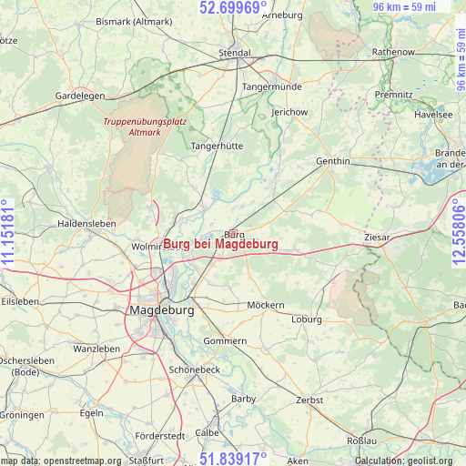
Burg bei Magdeburg GPS coordinates[2]
52° 16' 17.472" North, 11° 51' 17.748" East
| Map corner | latitude | longitude |
|---|---|---|
| Upper-left | 52.69969°, | 11.15181° |
| Center: | 52.27152°, | 11.85493° |
| Lower-right: | 51.83917°, | 12.55806° |
| Map W x H: | 95.7×95.7 km | = 59.5×59.5mi |
| max Lat: | 55.01917° ⇑25.2% North |
| Burg bei Magdeburg: | 52.27152° |
| min Lat: | ⇓74.8% South 47.40724° |
| min Long | Burg bei Magdeb | max Long |
| 5.92978° | 11.85493° | 14.98853° |
| W 79.6%⇐ | ⇒20.4% E |
Elevation
Elevation of Burg bei Magdeburg is 44 m = 144 ft, and this is 205.1 m = 673 ft below average elevation for this country.
| Max E: |
1256 m = 4121 ft | 81% |
| Avg. | 249.1 m = 817 ft | |
| Burg bei Magdeburg | 44 m = 144 ft | |
Min E: |
-5 m = -16 ft | 19% |
See also: Germany elevation on elevation.city.
Geographical zone
Burg bei Magdeburg is located in North temperate zone (between Tropic of Cancer and the Arctic Circle). Distance of this North polar circle is 1589.1 km =987.4 mi to North.| Distance of | km | miles | from Burg bei Magdeburg |
|---|---|---|---|
| North Pole | 4195 | 2606.7 | to North |
| Arctic Circle | 1589.1 | 987.4 | to North |
| Tropic Cancer | 3206.1 | 1992.2 | to South |
| Equator | 5812 | 3611.4 | to South |


Nearby cities:
15 places around Burg bei Magdeburg: (largest is in red/bold)
• Angern
12 km =7.5 mi,  316°
316°
• Farsleben
13.8 km =8.6 mi,  272°
272°
• Gerwisch
13.1 km =8.1 mi,  216°
216°
• Glindenberg
12.2 km =7.6 mi,  252°
252°
• Grabow
7.7 km =4.8 mi,  108°
108°
• Hohenwarthe
10.6 km =6.6 mi,  243°
243°
• Körbelitz
11.2 km =7 mi,  205°
205°
• Loitsche
10.9 km =6.8 mi,  285°
285°
• Lostau
10.6 km =6.6 mi,  228°
228°
• Möser
7.7 km =4.8 mi, 213°
• Reesen
5.8 km =3.6 mi,  75°
75°
• Rogätz
7.8 km =4.8 mi,  309°
309°
• Schermen
5.2 km =3.2 mi, 212°
• Theeßen
13.6 km =8.5 mi,  104°
104°
• Zielitz
12.4 km =7.7 mi,  279°
279°
Sources, notices
• [Note1] Compared only with cities in Germany existing in our database
• [Src1] Map data: © OpenStreetMap contributors (CC-BY-SA)
• [Src2] Other city data from geonames.org with taken over terms of usage.
• [Src3] Geographical zone / Annual Mean Temperature by Robert A. Rohde @ Wikipedia
