Lutzhorn geodata
Lutzhorn (Schleswig-Holstein) is a seat of a fourth-order administrative division; located in Germany in Europe/Berlin (GMT+2) time zone. With population of 798 people, there are 7909 cities with bigger population in this country. Compared to other cities in Germany, 90.3% of cities are located further ↓South; 53.2% of cities are located further →East and 90.5% of cities have higher elevation than Lutzhorn. Note1


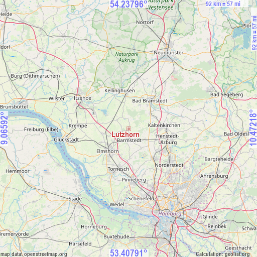
Lutzhorn GPS coordinates[2]
53° 49' 29.964" North, 9° 46' 8.58" East
| Map corner | latitude | longitude |
|---|---|---|
| Upper-left | 54.23796°, | 9.06592° |
| Center: | 53.82499°, | 9.76905° |
| Lower-right: | 53.40791°, | 10.47218° |
| Map W x H: | 92.3×92.3 km | = 57.4×57.4mi |
| max Lat: | 55.01917° ⇑9.7% North |
| Lutzhorn: | 53.82499° |
| min Lat: | ⇓90.3% South 47.40724° |
| min Long | Lutzhorn | max Long |
| 5.92978° | 9.76905° | 14.98853° |
| W 46.8%⇐ | ⇒53.2% E |
Elevation
Elevation of Lutzhorn is 20 m = 66 ft, and this is 229.1 m = 752 ft below average elevation for this country.
| Max E: |
1256 m = 4121 ft | 90.5% |
| Avg. | 249.1 m = 817 ft | |
| Lutzhorn | 20 m = 66 ft | |
Min E: |
-5 m = -16 ft | 9.5% |
See also: Germany elevation on elevation.city.
Geographical zone
Lutzhorn is located in North temperate zone (between Tropic of Cancer and the Arctic Circle). Distance of this North polar circle is 1416.4 km =880.1 mi to North.| Distance of | km | miles | from Lutzhorn |
|---|---|---|---|
| North Pole | 4022.3 | 2499.3 | to North |
| Arctic Circle | 1416.4 | 880.1 | to North |
| Tropic Cancer | 3378.9 | 2099.6 | to South |
| Equator | 5984.8 | 3718.8 | to South |


Nearby cities:
15 places around Lutzhorn: (largest is in red/bold)
• Barmstedt
3.7 km =2.3 mi,  181°
181°
• Bevern
7.7 km =4.8 mi, 179°
• Bokel
5.2 km =3.2 mi,  333°
333°
• Bokholt-Hanredder
4.6 km =2.9 mi,  207°
207°
• Brande-Hörnerkirchen
4.4 km =2.7 mi,  308°
308°
• Bullenkuhlen
6.6 km =4.1 mi,  190°
190°
• Groß Offenseth-Aspern
2.5 km =1.6 mi,  248°
248°
• Heede
5.1 km =3.2 mi,  156°
156°
• Heidmoor
5.4 km =3.4 mi,  80°
80°
• Hemdingen
7.7 km =4.8 mi,  146°
146°
• Klein Offenseth-Sparrieshoop
6.2 km =3.9 mi,  240°
240°
• Langeln
7.1 km =4.4 mi,  120°
120°
• Mönkloh
7.4 km =4.6 mi,  9°
9°
• Osterhorn
6.5 km =4 mi,  315°
315°
• Westerhorn
6.9 km =4.3 mi,  301°
301°
Sources, notices
• [Note1] Compared only with cities in Germany existing in our database
• [Src1] Map data: © OpenStreetMap contributors (CC-BY-SA)
• [Src2] Other city data from geonames.org with taken over terms of usage.
• [Src3] Geographical zone / Annual Mean Temperature by Robert A. Rohde @ Wikipedia
