Lüdersdorf geodata
Lüdersdorf (Mecklenburg-Vorpommern) is a populated place; located in Germany in Europe/Berlin (GMT+2) time zone. With population of 4,764 people, there are 2915 cities with bigger population in this country. Compared to other cities in Germany, 90.8% of cities are located further ↓South; 78% of cities are located further ←West and 73.6% of cities have higher elevation than Lüdersdorf. Note1
Administrative division(s):
- Level 1: Mecklenburg-Vorpommern
- Level 3: Nordwestmecklenburg
- Level 4: Lübberstorf


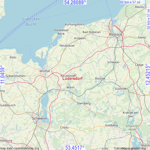
Lüdersdorf GPS coordinates[2]
53° 52' 6.06" North, 11° 44' 56.472" East
| Map corner | latitude | longitude |
|---|---|---|
| Upper-left | 54.28089°, | 11.0459° |
| Center: | 53.86835°, | 11.74902° |
| Lower-right: | 53.4517°, | 12.45215° |
| Map W x H: | 92.2×92.2 km | = 57.3×57.3mi |
| max Lat: | 55.01917° ⇑9.2% North |
| Lüdersdorf: | 53.86835° |
| min Lat: | ⇓90.8% South 47.40724° |
| min Long | Lüdersdorf | max Long |
| 5.92978° | 11.74902° | 14.98853° |
| W 78%⇐ | ⇒22% E |
Elevation
Elevation of Lüdersdorf is 69 m = 226 ft, and this is 180.1 m = 591 ft below average elevation for this country.
| Max E: |
1256 m = 4121 ft | 73.6% |
| Avg. | 249.1 m = 817 ft | |
| Lüdersdorf | 69 m = 226 ft | |
Min E: |
-5 m = -16 ft | 26.4% |
See also: Germany elevation on elevation.city.
Geographical zone
Lüdersdorf is located in North temperate zone (between Tropic of Cancer and the Arctic Circle). Distance of this North polar circle is 1411.6 km =877.1 mi to North.| Distance of | km | miles | from Lüdersdorf |
|---|---|---|---|
| North Pole | 4017.5 | 2496.4 | to North |
| Arctic Circle | 1411.6 | 877.1 | to North |
| Tropic Cancer | 3383.7 | 2102.5 | to South |
| Equator | 5989.6 | 3721.8 | to South |


Nearby cities:
15 places around Lüdersdorf: (largest is in red/bold)
• Benz
11.7 km =7.3 mi,  293°
293°
• Bernitt
9.9 km =6.2 mi,  66°
66°
• Brüel
14.8 km =9.2 mi,  188°
188°
• Glasin
4.9 km =3 mi,  350°
350°
• Hornstorf
14.9 km =9.3 mi, 288°
• Jesendorf
12.1 km =7.5 mi,  233°
233°
• Jürgenshagen
13.6 km =8.5 mi,  45°
45°
• Lübow
14.8 km =9.2 mi,  263°
263°
• Neukloster
4.2 km =2.6 mi,  265°
265°
• Rühn
13.6 km =8.5 mi,  112°
112°
• Sellin
9.4 km =5.8 mi,  281°
281°
• Ventschow
14.2 km =8.8 mi, 230°
• Warin
8.1 km =5 mi,  200°
200°
• Warnow
12.6 km =7.8 mi,  136°
136°
• Zurow
8.8 km =5.5 mi, 267°
Sources, notices
• [Note1] Compared only with cities in Germany existing in our database
• [Src1] Map data: © OpenStreetMap contributors (CC-BY-SA)
• [Src2] Other city data from geonames.org with taken over terms of usage.
• [Src3] Geographical zone / Annual Mean Temperature by Robert A. Rohde @ Wikipedia
